Ginjo Thakurgaon
Ginjo Thakurgaon is a village situated in the northern region of the Ranchi district (Burmu block) in Jharkhand. It is about 25 km north-west of Ranchi, the capital city of Jharkhand. The village is bounded by Mandar, Burmu, Pithauria, Chund and Ratu.
Ginjo Thakurgaon Thakurgaon | |
|---|---|
Village | |
 Ginjo Thakurgaon Location in Jharkhand, India  Ginjo Thakurgaon Ginjo Thakurgaon (India) | |
| Coordinates: 23.52°N 85.17°E | |
| Country | |
| State | Jharkhand |
| District | Ranchi |
| Elevation | 625 m (2,051 ft) |
| Population | |
| • Total | 10,000 |
| Languages | |
| • Official | Hindi, Nagpuri |
| Time zone | UTC+5:30 (IST) |
| PIN | 835205 |
| Telephone code | 06531 |
| Vehicle registration | JH-01 |
| Distance from Ranchi | 25 kilometres (16 mi) NW |
Monday and Thursday each weekly haat or market in Ginjo Thakurgaon where people come from different villages and shopping. Otherwise, the main vegetable market are Brambe and Makhmandro (Katulahna) for the farmer where they can sell their own vegetable.
Forest Research Center at Mandar and Patratu Thermal Power Station at Patratu, Hazaribagh are within a short distance.
Geography
Ginjo Thakurgaon is located at 23.52°N 85.17°E.[1] It has an average elevation of 625 m (2,051 ft).
Places of interest
| SNo | Name Of the Place | Interest For | Distance From City | Way of |
|---|---|---|---|---|
| 1. | Bhawani Shankar Mandir (भवानी शंकर मन्दिर) | Religious Temple | Centre Of the City | School Road |
| 2. | ESS EMM COMPUTER CENTER devi mandap | Religious Temple | Centre Of the City | School Road |
| 3. | Bhoor Nadi (Aikashi Mahadeo भुर नदी (ऐकैशी महादेव) | Religious | 3-5 km | Ginjo Thakurgaon Mandar Road |
| 4. | Kanke Dam, Ranchi | Tourist | 25 km | Kanke Road |
| 5. | Gonda Hill, Ranchi | Tourist | 25 km | Kanke Road |
| 6. | Rock Garden, Ranchi | Tourist | 25 km | Kanke Road |
| 7. | Pahari Mandir, Ranchi | Tourist | 25 km | Ratu Road |
| 8. | Ranchi Lake, Ranchi | Tourist | 25 km | Ranchi |
| 9. | Tagore Hill, Ranchi | Tourist | 30 km | Bariatu Road |
| 10. | Ormanjhi National Park (Birsa Zoological Park), Ranchi | National Park | 35 km | NH 33 |
| 11. | Deer Park | National Park | 40 km | Ranchi - Khunti Road |
| 12. | Dasham Fall | Tourist | 60 km | Ranchi - Tata Road |
| 13. | Hundru Fall | Tourist | 50 km | Ranchi - Purulia Road |
| 14. | Jonha Fall | Tourist | 50 km | Ranchi - Purulia Road |
| 15. | Hirni Fall | Tourist | 90 km | Ranchi - Chaibasa Road |
| 16. | Panchghagh Fall | Tourist | 70 km | Ranchi - Chaibasa Road |
| 17. | Sun temple | Religious | 45 km | Ranchi - Tata Road |
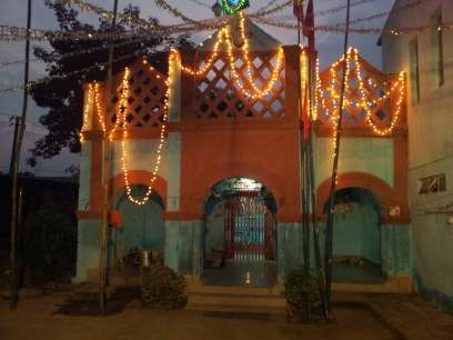
Bhawani Shankar Mandir (भवानी शंकर मन्दिर)
Schools
| SNo | Name Of the School | Co-Education | Government / Private |
|---|---|---|---|
| 1. | Bhawani Shankar High School | No - (Boys) | Government |
| 2. | Rajyakrit Madhyamik Vidyalaya | No - (Boys) | Government |
| 3. | Rajyakrit Kanya Madhyamik Vidyalaya | No - (Girls) | Government |
| 4. | Project Kanya High School | No - (Girls) | Government |
| 5. | Saraswati Shishu Mandir | Yes | Private |
| 6. | Adivasi Bal Vikas Vidyalaya | Yes | Private |
Communication
| SNo | Provider | Technology |
|---|---|---|
| 1 | BSNL | Landline, GSM & CDMA |
| 2 | Reliance | GSM & CDMA |
| 3 | AirTel | GSM |
| 4 | Vodafone | GSM |
| 5 | IDEA | GSM |
| 6 | AIRCEL | GSM |
| 7 | UNINOR | GSM |
| "8" | JIO | GSM |
gollark: ~~technically it's reverse engineering *and* maybe cheating~~
gollark: `/lineage/[code of egg]` used to work on cave eggs.
gollark: (This is what I think of the raffle, actually)
gollark: Even better, apply this to 1 in 100 people, because random means fair!
gollark: What *could* go wrong?!
This article is issued from Wikipedia. The text is licensed under Creative Commons - Attribution - Sharealike. Additional terms may apply for the media files.