Gilgit District
Gilgit District (Urdu: ضلع گلگت) is one of the districts of the Gilgit–Baltistan territory in northern Pakistan. It was formed in 1970 when Gilgit–Baltistan was federally administered as the "Northern Areas". It is bounded by the Wakhan Corridor (Afghanistan) to the north; Xinjiang (China) to the northeast and east; Skardu, Astore and Diamer to the south; and Ghizer District to the west. The town of Gilgit is the capital of Gilgit District. According to the 1998 census Gilgit District had a population of 243,324.
Gilgit District | |
|---|---|
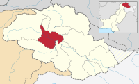 Map of Gilgit–Baltistan, showing the six districts and tehsil boundaries. | |
| Country | |
| Autonomous territory | |
| Capital | Gilgit |
| Established | July 1, 1970 |
| Area | |
| • Total | 38,000 km2 (15,000 sq mi) |
| Population (1998) | |
| • Total | 243,324 |
| • Density | 6.4/km2 (17/sq mi) |
| Time zone | UTC+5 (PST) |
| Number of Tehsils | 4 |
The district includes Gilgit (the capital city), the Bagrot Valley, Juglot, Danyore, Sultanabad, Naltar Peak, and the Nomal Valley. The highest peak in the district is Distaghil Sar 7,885 metres (25,869 ft), which is the seventh-highest peak in Pakistan and 19th-highest on Earth.
Administration
In 2009 the Pakistan's People's Party Government of Pakistan changed the status of the Northern Areas through a presidential ordinance and has renamed it as Gilgit–Baltistan. The present Governor is Mir Ghazanfar, who is the constitutional head of the de facto provincial setup, assisted by an executive Chief Minister - Hafiz Hafeez ur Rehman - and a council of ministers.
Administration is by a tailor-made political and local government system. The local government system is based on a Legislative Council (Provincial Assembly), elected by people in all six districts through voting, and headed by a speaker. Technocrats and women members are later elected/selected through a proper system.
The Chief Secretary is the administrative head of all departments, controlling all the affairs on behalf of the Chief Minister Government of Pakistan.
An Inspector General of Police heads the police department, with deputy superintendents in all six districts.
Judiciary
The main judicial structure in Gilgit–Baltistan comprises a High Court, composed of three judges selected by the government, supported by the Supreme Appellate Court.
Education
According to the Alif Ailaan Pakistan District Education Rankings 2015, Gilgit is ranked 35 out of 148 districts in terms of education. For facilities and infrastructure, the district is ranked 67 out of 148.[1]
Geography
Only a part of the basin of the Gilgit River, i.e. Gilgit Valley, is included within the political boundaries of Gilgit District. There is an intervening width of mountainous country, represented chiefly by glaciers and ice fields, and intersected by narrow sterile valleys, measuring some 100 metres (330 ft) to 150 metres (490 ft) in width, to the north and north-east, which separates the province of Gilgit from the Chinese frontier beyond the Muztagh and Karakoram. Towering above Gilgit is Mount Rakaposhi at 7,788 metres (25,551 ft).
Rivers
The main rivers in the District are:
- Khunjerab River - flows south along the Karakoram Highway from the Khunjerab Valley, known as Hunza River in the south of Sust
- Hunza River - flows further south and falls into Gilgit River just in the northeast of Gilgit town
- Gilgit River - enters Gilgit District from west in the south of Bichhar Pass (Naltar Valley) and flows west through the Gilgit town.
- Indus River - enters Gilgit District from Skardu District about six kilometers north of Jaglot where Gilgit River falls into Indus River and the Indus flows south along the Karakoram Highway.
- Astor River
There are many tributaries of the above main rivers, some of which are Ghujerab River, Shimshal River, Hispar River, Naltar River and Yaheen River.
Passes
- Khunjerab Pass, Mintika Pass, Kilik Pass, Chillingi Pass, Shimshal Pass, Ghujerab Pass, Chapchingal Pass, Chaprot Pass, Naltar Pass and Talmutz Pass.
See also
- Districts of Gilgit–Baltistan
- 1988 Gilgit Massacre
References
| Wikimedia Commons has media related to Gilgit District. |
- "Individual district profile link, 2015". Alif Ailaan. Archived from the original on 2016-08-17. Retrieved 2015-05-07.
| Passes | |
|---|---|
| Valleys |
|
| Cities and towns |
|
| Rivers, glaciers and lakes | |
| Architecture | |
| See also | |