Georgia State Route 186
State Route 186 (SR 186) is a state highway in the north-central part of the U.S. state of Georgia. It runs west-east within portions of Walton and Oconee Counties.
| ||||
|---|---|---|---|---|
| High Shoals Road | ||||
 | ||||
| Route information | ||||
| Maintained by GDOT | ||||
| Length | 11.2 mi[1] (18.0 km) | |||
| Major junctions | ||||
| West end | ||||
| East end | ||||
| Location | ||||
| Counties | Walton, Oconee | |||
| Highway system | ||||
| ||||

Route description
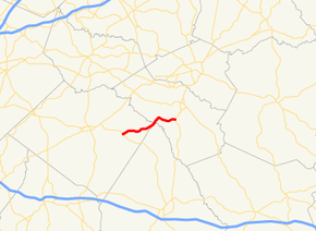
The route begins at an intersection with SR 83 in Good Hope, in Walton County. It heads northeast until it crosses the Apalachee River (where it transitions into Oconee County) and enters North High Shoals, where the route becomes more easterly. Just north of the city limits of Bishop, it meets its eastern terminus, an intersection with US 129/US 441/SR 24.
Major intersections
| County | Location | mi[1] | km | Destinations | Notes |
|---|---|---|---|---|---|
| Walton | Good Hope | 0.0 | 0.0 | Western terminus | |
| Apalachee River | 6.7 | 10.8 | Unnamed bridge; Walton–Oconee county line | ||
| Oconee | | 11.2 | 18.0 | Eastern terminus | |
| 1.000 mi = 1.609 km; 1.000 km = 0.621 mi | |||||
gollark: It's impressive that my computer is capable of executing several billions (hundreds of billions on the GPU) of operations per second and yet is apparently still loaded at 50% just idling with a bunch of tabs and VSCode open.
gollark: This is due to its unsafety.
gollark: GTech™ actually uses all instances of C-style memory management to inject monitoring drones.
gollark: It should *work*, though.
gollark: The dependency management is kind of awful.
See also
.svg.png)

References
- Google (June 5, 2013). "Route of SR 186" (Map). Google Maps. Google. Retrieved June 5, 2013.
External links
This article is issued from Wikipedia. The text is licensed under Creative Commons - Attribution - Sharealike. Additional terms may apply for the media files.