Geology of Gotland
Gotland is made up of a sequence of sedimentary rocks of a Silurian age, dipping to the south-east. The main Silurian succession of limestones and shales comprises thirteen units spanning 200–500 m (660–1,640 ft) of stratigraphic thickness, being thickest in the south, and overlies a 75–125 m (246–410 ft) thick Ordovician sequence.[1] Precambrian shield rocks that underlie these sediments are found 400 to 500 meters sea level.[2] Sedimentary rocks cropping out in Gotland were deposited in a shallow, hot and salty sea, on the edge of an equatorial continent.[3] The water depth never exceeded 175–200 m (574–656 ft),[4] and shallowed over time as bioherm detritus, and terrestrial sediments, filled the basin. Reef growth started in the Llandovery, when the sea was 50–100 m (160–330 ft) deep, and reefs continued to dominate the sedimentary record.[1] Some sandstones are present in the youngest rocks towards the south of the island, which represent sand bars deposited very close to the shore line.[5]


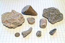
The lime rocks have been weathered into characteristic karstic rock formations known as rauks. Fossils, mainly of rugose corals and brachiopods, are abundant throughout the island; palæo-sea-stacks are preserved in places.[6]
The rocks of Gotland display signals of global extinction events, which take their name from parishes on the island: the Ireviken, Mulde and Lau events.
Stratigraphy

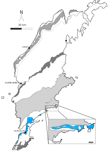
The island is composed of the following formations, listed from youngest to oldest (i.e. from south to north).[7]
- Sundre Formation – Ludlow (upper Silurian)
- Hamra Formation
- Burgsvik Formation – terrestrial input; deposited during regression
- Eke Formation
- Hemse Formation
- Klinteburg Formation
- Fröjel Formation – terrestrial input; deposited during regression and topped with erosional sequence boundary.
- Halla Formation
- Slite Group
- Lower & Upper Visby Formation
- Tofta Formation
- Högklint Formation – Silurian[8]
Quaternary geology

Gotland has mostly a subdued relief composed of flat erosion surfaces. Higher areas usually correspond to those of more-less pure limestone while lower areas have commonly a geology of marl.[2] The reason for this is that limestone is more resistant to erosion than marl.[9] Another general relief feature is that northwestern margin of the island is higher than the southeastern parts.[2] This higher northwestern coast is in part result of the southeast tilt of the sedimentary strata.[10] The northwest coast is straight and contain active cliffs.[2][10] On the other side the eastern coastline is irregular and sinuous.[10]
During large Quaternary glaciations Gotland was covered by an ice sheet. The effects of Quaternary glacial erosion are not as visible in Gotland as they are in mainland Sweden because of its sedimentary basement. Glaciation did however left thin blankets of fine-grained boulder-clay till. The boulder include rocks of Archean age transported from far-away regions of Fennoscandia. Where the till blanket is absent the bare rock surfaces are exposed.[2]
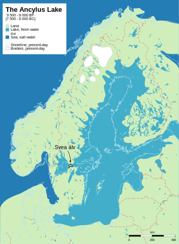
At the end of the last glaciation Gotland was fully summerged in the waters of the proto-Baltic Sea. The Ancylus and Litorina transgressions left marks in form of beaches. These beaches are now located above current sea level due to post-glacial rebound and changes in sea level. Compared to the rest of Sweden Gotland host good examples of active coastal processes.[2]
There are few traces of river and stream erosion in Gotland. Some drainage in the island occurs through karstic systems, including caves.[2] The soils of Gotland are thin with calcareous till clay being the main parent material.[10]
Economic geology
The particular geology of Gotland has conditioned many aspects of human life and economic activity. The economic activities influenced by geology include forestry, farming, cement production and quarrying building stones.[11]

During the industrial age demand for Gotland limestone came from pulp mills, sugar refineries and iron works. People working in the quarries of Gotland have diminished from about 600 in the mid-1930s to 350 by 2010.[12] The intended opening of a new limestone quarry in the 2010s in northern Gotland has led to a substantial conflict between environmentalists and those who support the project.[13] In April 2015, the legal process regarding the allowance of the project was put on hold by Swedish courts until the Swedish government takes a decision or, if not, until August 31 of 2015.[14]
Exploratory wells have revealed the existence of petroleum oil of Lower Paleozoic age beneath Gotland.[15]
References
- Laufeld, S. (1974). Silurian Chitinozoa from Gotland (PDF). Fossils and Strata. Universitetsforlaget.
- Rudberg, Sten (1967). "The cliff coast of Gotland and the rate of cliff retreat". Geografiska Annaler. 49 (2): 283–298. doi:10.2307/520895. JSTOR 520895.
- Creer, K. M (1973). Tarling, D. H.; Runcorn, S. K. (eds.). "A discussion of the arrangement of palaeomagnetic poles on the map of Pangea for Epochs in the Phanerozoic". Implications of Continental Drift to the Earth Sciences L. London, New York: Academic Press: 47–76.
- Gray, Jane; Laufeld, Sven; Boucot, A.J. (19 July 1974). "Silurian Trilete Spores and Spore Tetrads from Gotland: Their Implications for Land Plant Evolution". Science. Science. 185 (4147): 260–263. doi:10.1126/science.185.4147.260. PMID 17812053.
- Long, D.G.F. (1993). "The Burgsvik beds, an Upper Silurian storm generated sand ridge complex in southern Gotland". Geologiska Föreningens I Stockholms Förhandlingar (GFF). 115 (4): 299–309. doi:10.1080/11035899309453917. ISSN 0016-786X.
- Laufeld, Sven; Martinsson, Anders (22–28 August 1981). "Reefs and ultrashallow environments. Guidebook to the field excursions in the Silurian of Gotland". Project Ecostratigraphy Plenary Meeting.
- "The Silurian Mulde Event and a scenario for secundo–secundo events". Transactions of the Royal Society of Edinburgh: Earth Sciences. 93 (2): 135. 2002. doi:10.1017/S0263593302000093.
- Eliason et al. 2010, p. 17
- Eliason et al. 2010, p. 11
- Behrens, Sven. "Gotland: Terrängformer". Nationalencyklopedin (in Swedish). Cydonia Development. Retrieved November 30, 2017.
- Eliason et al. 2010, p. 5
- Eliason et al. 2010, p. 41
- Liljebäck, Lars-Erik. "Kalkbrottet som delar Gotland". Naturvetarna (in Swedish). Naturvetarna. Retrieved July 13, 2015.
- "Mål om kalkbrytning på Gotland skjuts upp". Dagens Nyheter (in Swedish). April 10, 2015.
- Zdanaviciute, O.; Lazauskiene, J.; Khoubldikov, A.I.; Dakhnova, M.V.; Zheglova, T.P. (2013). The Hydrocarbon Potential of the Baltic Basin: Geochemistry of Source Rocks and Oils of the Lower Paleozoic Succession. Beijing, China: AAPG Hedberg Conference.
Bibliography
- Eliason, Sara; Bassett, Michael G.; Willman, Sebastian (2010). Geotourism highlights of Gotland. Tallinn. pp. 5, 41. ISBN 978-9985-9973-4-5.
Further reading
For a reconstruction of the facies of Gotland, presented as an east-west section, see page 25 of:
- Samtleben, C.; Munnecke, A.; Bickert, T. (2000). "Development of facies and C/O-isotopes in transects through the Ludlow of Gotland: Evidence for global and local influences on a shallow-marine environment". Facies. 43 (1): 1–38. doi:10.1007/BF02536983.