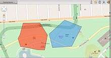
Geo-fence
A geofence is a virtual perimeter for a real-world geographic area.[1] A geo-fence could be dynamically generated—as in a radius around a point location, or a geo-fence can be a predefined set of boundaries (such as school zones or neighborhood boundaries).

The use of a geofence is called geofencing, and one example of usage involves a location-aware device of a location-based service (LBS) user entering or exiting a geo-fence. This activity could trigger an alert to the device's user as well as messaging to the geo-fence operator. This info, which could contain the location of the device, could be sent to a mobile telephone or an email account.
Applications
Geofencing, used with child location services, can notify parents if a child leaves a designated area.[2]
Geofencing used with locationized firearms can restrict those firearms to fire only in locations where their firing is permitted, thereby making them unable to be used elsewhere.
Geofencing is critical to telematics. It allows users of the system to draw zones around places of work, customer's sites and secure areas. These geo-fences when crossed by an equipped vehicle or person can trigger a warning to the user or operator via SMS or email.
In some companies, geofencing is used by the human resource department to monitor employees working in special locations especially those doing field works. Using a geofencing tool, an employee is allowed to log his or her attendance using a GPS-enabled device when within a designated perimeter.
Other applications include sending an alert if a vehicle is stolen,[3] and notifying rangers when wildlife stray into farmland.[4]
Geo-fence can be used for location based messaging for tourist safety and communication.[5]
Geofencing, in a security strategy model, provides security to wireless local area networks. This is done by using predefined borders (e.g., an office space with borders established by positioning technology attached to a specially programmed server). The office space becomes an authorized location for designated users and wireless mobile devices.[6]
In 2015, US Senator Charles Schumer proposed a law requiring drone manufacturers to build geofencing constraints into unmanned aerial vehicle navigation systems that would override the commands of the unsophisticated operator, preventing the device from flying into protected airspace.[7][8]
Applications of Geofencing extend to Advertising & Marketing. Geofencing solution providers allow marketers and advertisers to precisely choose the exact geo-location that their ads show up on. Geofencing uses different types of targeting to identify geo-location such as zip codes, street addresses, GPS coordinates using latitude and longitude, as well as IP targeting.
Geofencing enables competitive marketing tactics for advertisers and marketers to grab the attention of in-market shoppers in their competitive store location, large scale events such as concerts, sports events, conferences, etc. in stadiums, convention centers, malls, outlets, parks, neighborhoods.
For example, a local auto-dealership builds a virtual boundary within a few square miles from its dealership's location to target car buyers within the same neighborhood. This way they limit their ad spending on prospects who are more likely to purchase in order to get a better ROI. Using tracking technologies to identify devices where the ads were shown, geofencing solution providers are able to provide walk-in attribution for their advertising. This means that using a geofencing solution, companies can now track the customers who walked into the showroom after seeing the ad. This level of attribution provides better visibility and analytics for marketers to spend their advertising budget wisely.
A local service business may only be interested in (a) likely clients (b) within a service region or catchment basin. Broadcasting or advertising more extensively brings irrelevant responses and wastes energy, time, money, and opportunity. Electronic advertising can identify and target only desired market objects.
See also
References
- Rouse, Margaret (December 2016). "What is geo-fencing (geofencing)?". WhatIs.com. Newton, Massachusetts: TechTarget. Retrieved 26 Jan 2020.
- De Lara, Eyal; Anthony LaMarca; Mahadev Satyanarayanan (2008). Location Systems: An Introduction to the Technology Behind Location Awareness. Synthesis Lectures on Mobile and Pervasive Computing, Lecture #4. Morgan & Claypool Publishers. p. 88. ISBN 978-1-59829-581-8 – via Google Books.
- "Motorcycle Tracker Updates Every 15 Seconds". Motorcycle USA. 23 January 2009. Archived from the original on January 31, 2009. Retrieved 2009-01-26.
Courtesy True Tracker Pro
- "Kenya's elephants send text messages to rangers". CBS News. Associated Press. October 11, 2008. Retrieved 26 Jan 2020.
- "Location Based Messaging for Tourist Safety and Communication" (PDF). UgoRound Australia Pty Ltd. July 2017. Retrieved 26 Jan 2020.
- Hamid Jahankhani, A G Hessami, Feng Hsu: Global security, safety, and sustainability : 5th international conference, ICGS3 2009, London, UK, September 1-2, 2009 : proceedings. ISBN 978-3-642-04061-0
- "Todd Humphreys: Don't Overregulate Drones". Alcalde. 18 March 2015. Retrieved 2015-04-05.
- Schumer, Charles (19 August 2015). "Schumer proposes law". Retrieved 15 December 2015.
Further reading
- De Lara, Eyal; Anthony LaMarca, Mahadev Satyanarayanan (2008). Location Systems: An Introduction to the Technology Behind Location Awareness. Morgan & Claypool Publishers. p. 88. ISBN 978-1-59829-581-8.
- Anthony C. Ijeh, Allan J. Brimicombe, David S. Preston, Chris O. Imafidon (2009) "Geofencing in a Security Strategy Model." In Global Safety and Sustainability: 5th International Conference Proceedings. Jahankhani, H.; Hessami, A.G.; Hsu, F. (Eds.) p.104-111 © Springer-Verlag Berlin Heidelberg 2009. ISBN 978-3-642-04061-0