Garrykennedy
Garrykennedy (Garraí Uí Chinnéide in Irish)[1] is a townland, settlement and harbour in the historical Barony of Owney and Arra, County Tipperary, Ireland. It is located on the eastern shore of Lough Derg, 2 km north of Portroe
Garrykennedy Garraí Uí Chinnéide | |
|---|---|
Village | |
 | |
| Country | Ireland |
| Province | Munster |
| County | Tipperary |
| Barony | Owney and Arra |
| Civil parish | Castletownarra |
| Townland | Garrykennedy |
| Elevation | 33 m (108 ft) |
| Population (2016) | |
| • Total | 215 |
Buildings and structures of note
Garrykennedy Castle, a ruined tower house located beside the water was once an O'Kennedy clan home built in the 15th Century. By the mid-17th Century the castle was already a ruin.
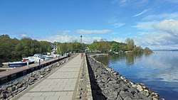
The harbour was once important for transporting goods, particularly slate from nearby mines. The present quay, built about 1780 is classified as being of Architectural, Archaeological and Technical interest but is now a leisure facility with a modern marina nearby. Cruisers are particularly attracted here by the local pubs, known for their food and music.[2][3]
St Mary's Church, a detached gable front building with bellcote from 1872. Stained glass, arched windows and mouldings are signs of skilled craftsmen.This small church is notable for Architectural, Artistic and Social reasons.[4]
An old Tug of War training device lies in a field around 400m south-west of the harbour.
The older harbour has many abandoned boats there.
Recreation
Garrykennedy has a sailing club which organises races and social events during the summer.[5]
There is also a Fishing Club. The club holds fishing competitions and has a policy to encourage young people into the sport. It is also active in stream rehabilitation projects in the area.[6]
Garrykennedy Duck sanctuary is located near the quay.[7]
The Lough Derg Way, a long-distance trail begins in Limerick City and passes through Garrykennedy on its way to Dromineer. It is designated as a National Waymarked Trail by the National Trails Office of the Irish Sports Council and is managed by Shannon Development, Tipperary County Council and Tipperary Integrated Development Company.[8] The trail was reconfigured and relaunched in 2011 with many sections taken off-road aided by an investment of €115,000 under the Comhairle na Tuaithe Walks Scheme, which supports landowners to maintain trails that cross their land.[9][10] The trail connects with the East Clare Way at Killaoe.[10]
There is a signposted walk through the nearby woods and more unmarked trails. A small rocky shore often referred to as the flat rocks or slippy rock is on the walk. There are also wooden scupltures in the forest and chairs made out of chopped down trees.
There is a playground in the harbour made out of wood and multiple barbeque spots for families to cook food.
Housing & Settlements
Most of the population is near the harbour. There is no social housing or housing estates and all the housing are either bungalow or 2-story. Most housing is heated by oil.[11][12]
Nature & Geography
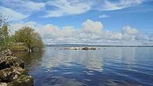
The area is mostly flat with slopes gradually rising towards the Arra Mountains. Two streams flow into Lough Derg on each side of the village. Garrykennedy forest has mixture of trees but mostly contains ash, oak and spruce. The shore is home to many waterfowl and the forest is home to many small mammals. A family of swans live on the shore and lay eggs on islands nearby. Some minks live at the shore as well. A herron and a cormorant can be spotted on the lake.
References
- "Bunachar Logainmneacha na hÉireann - Placenames Database of Ireland". logainm.ie. Retrieved 21 May 2013.
- "Garrykennedy Castle and Old Harbour - Lough Derg". Ireland Highlights. Retrieved 21 May 2013.
- "Tipperary North: Buildings of Ireland: National Inventory of Architectural Heritage". Buildingsofireland.ie. Retrieved 21 May 2013.
- "Saint Mary's Roman Catholic Church, Tipperary North: Buildings of Ireland: National Inventory of Architectural Heritage". Buildingsofireland.ie. Retrieved 21 May 2013.
- http://www.garrykennedysailing.com
- "Fishing in Ireland. An angler's guide to the best fishing in Ireland". Shannon-fishery-board.ie. Retrieved 21 May 2013.
- "Information About Garrykennedy, Ireland - LeBoat". Leboat.ie. Retrieved 21 May 2013.
- National Trails Office 2010, p. 39.
- "New look Lough Derg Way relaunched". The Nenagh Guardian. Nenagh. 19 March 2011. p. 8.
- "Lough Derg Way Map" (PDF). Shannon Region Trails. Archived from the original (PDF) on 28 March 2012. Retrieved 2 August 2011.
- http://census.cso.ie/sapmap2016/Results.aspx?Geog_Type=SA2017&Geog_Code=4c07d11e-0e57-851d-e053-ca3ca8c0ca7f
- https://larkins.ie/history-of-garrykennedy/