Garnedd-Wen Formation
The Garnedd-Wen Formation (also known as the Garnedd-Wen Beds) is an Ordovician lithostratigraphic group (a sequence of rock strata) in Mid Wales. The rock of the formation is a mixture of mudstones, siltstones, fine- to coarse-grained sandstones, greywackes and conglomerates.[1] The formation extends from Dinas Mawddwy in the north-east to Tywyn in the south-west.[2]
| Garnedd-Wen Formation Stratigraphic range: Hirnantian Age | |
|---|---|
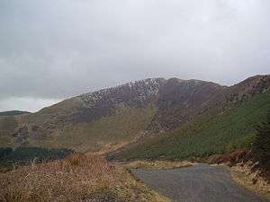
 The upper slopes of Tarren y Gesail are primarily in the Garnedd-Wen Formation | |
| Type | Group |
| Unit of | Abercorris Group |
| Overlies | Narrow Vein Mudstone Formation |
| Thickness | 1,000 metres (3,300 ft) to 3,000 metres (9,800 ft) |
| Lithology | |
| Primary | Mudstone |
| Other | Sandstone |
| Location | |
| Region | Mid Wales |
| Country | Wales |
| Extent | Tywyn to Dinas Mawddwy |
| Type section | |
| Named for | Garneddwen |
Geography
The Garnedd-Wen Formation is the upper strata of rock across a wide part of western Mid Wales. In particular, it forms the upper rock beds of the Tarren Hills on the south side of the Bala Fault, west of Talyllyn Lake.[3]
gollark: Like potatOS.
gollark: You should, instead, add a metatable to numbers and modify that.
gollark: pjals' code is basically an infohazard.
gollark: OR WILL IT?
gollark: I just sort anything pjals does into the "probably broken horribly" bucket.
References
- "Garnedd-Wen Formation". BGS on-line lexicon of rock units. British Geological Survey. Retrieved 11 September 2019.
- P. J. Brenchley (2006). The Geology of England and Wales. Geological Society of London. pp. 74–. ISBN 978-1-86239-200-7.
- W. T. Pratt; D. G. Woodhall; Malcolm Fletcher Howells; M. J. Leng (1995). Geology of the Country Around Cadair Idris. H.M. Stationery Office. ISBN 978-0-11-884509-0.
This article is issued from Wikipedia. The text is licensed under Creative Commons - Attribution - Sharealike. Additional terms may apply for the media files.