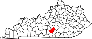
Garlin, Kentucky
Garlin is an unincorporated community in Adair County, Kentucky, United States. Its elevation is 892 feet (272 m).[1]
Garlin | |
|---|---|
 Garlin Location within the state of Kentucky  Garlin Garlin (the United States) | |
| Coordinates: 37°6′50″N 85°15′8″W | |
| Country | United States |
| State | Kentucky |
| County | Adair |
| Elevation | 892 ft (272 m) |
| Time zone | UTC-6 (Central (CST)) |
| • Summer (DST) | UTC-5 (CDT) |
| GNIS feature ID | 492704 |
History
A post office was established in the community in 1903, and probably named for its first postmaster.[2]
gollark: Chromebooks and iPhones and kind of Android phones/tablets (especially on newer versions) use general purpose processors, but with locked bootloaders and limited OSes. Generally to give the company making them a monopoly on app distribution/data gathering and to make DRM schemes "work".
gollark: Or, well, try to.
gollark: There seems to be an increasing trend to make computing stuff not general-purpose, which is annoying.
gollark: Phones are general-purpose computers, regardless of how much the companies don't really want that.
gollark: I have a Linux-y terminal with Python and whatnot available.
References
- U.S. Geological Survey Geographic Names Information System: Garlin, Kentucky
- Rennick, Robert M. (1987). Kentucky Place Names. University Press of Kentucky. p. 113. ISBN 0813126312. Retrieved 2013-04-28.
This article is issued from Wikipedia. The text is licensed under Creative Commons - Attribution - Sharealike. Additional terms may apply for the media files.
