GOES 6
GOES-6, known as GOES-F before becoming operational, was a geostationary weather satellite which was operated by the United States National Oceanic and Atmospheric Administration as part of the Geostationary Operational Environmental Satellite system.[1] Launched in 1983, it was used for weather forecasting in the United States.
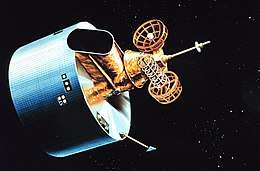 Artist's impression of an HS-371 derived GOES satellite | |
| Mission type | Weather satellite |
|---|---|
| Operator | NOAA / NASA |
| COSPAR ID | 1983-041A |
| SATCAT no. | 14050 |
| Mission duration | 7 years (planned) 6 years (VISSR) 9 years (achieved) |
| Spacecraft properties | |
| Bus | HS-371 |
| Manufacturer | Hughes |
| Launch mass | 660 kilograms (1,460 lb) |
| Start of mission | |
| Launch date | 28 April 1983, 22:26 UTC |
| Rocket | Delta 3914 |
| Launch site | Cape Canaveral LC-17A |
| Contractor | McDonnell Douglas |
| End of mission | |
| Disposal | Decommissioned |
| Deactivated | 19 May 1992 |
| Orbital parameters | |
| Reference system | Geocentric |
| Regime | Geostationary |
| Longitude | 135° West (1983-1984) 97° West (1984) 108° West (1984-1987) 135° West (1987-1992) |
| Slot | GOES-WEST (1983-1984, 1987-1992) |
| Semi-major axis | 42,151.0 kilometers (26,191.4 mi) |
| Perigee altitude | 35,759.4 kilometers (22,219.9 mi) |
| Apogee altitude | 35,800.9 kilometers (22,245.6 mi) |
| Inclination | 14.7° |
| Period | 1,435.1 minutes |
GOES-6 was built by Hughes Space and Communications, and was based on the HS-371 satellite bus. At launch it had a mass of 660 kilograms (1,460 lb),[2] with an expected operational lifespan of around seven years.
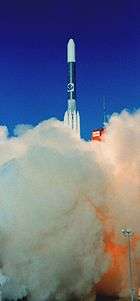
Launch
GOES-F was launched using a Delta 3914 carrier rocket[3] flying from Launch Complex 17A at the Cape Canaveral Air Force Station.[4] The launch occurred at 22:26 GMT on 28 April 1983.[5]
Orbit
The launch successfully placed GOES-F into a geosynchronous transfer orbit, from which it raised itself to geostationary orbit by means of an onboard Star 27 apogee motor, with insertion occurring on 9 May 1983.[6]
Following insertion into geosynchronous orbit, GOES-6 was positioned at 135° West. In 1984 it was moved, initially to 97° West, and later to 108° West to cover for the failure of the Visible Infrared Spin-Scan Radiometer on GOES-5. After GOES-7 replaced GOES-5 in 1987, GOES-6 was returned to 135° West, where it remained for the rest of its operational life.[4] Its imager had failed on 21 January 1989,[1] leaving GOES-7 as the only operational GOES satellite for over five years, until the launch of GOES-8 in 1994. Following this failure, it remained operational as a relay satellite until it was retired to a graveyard orbit on 19 May 1992.[1][6]
See also
References
- "GOES-6". The GOES Program - ESE 40th Anniversary. NASA. Retrieved 2009-08-15.
- "GOES-6". NSSDC Master Catalog. US National Space Science Data Center. Retrieved 2009-08-15.
- Krebs, Gunter. "GOES 4, 5, 6, G, 7". Gunter's Space Page. Retrieved 2009-08-15.
- Wade, Mark. "GOES". Encyclopedia Astronautica. Retrieved 2009-08-15.
- McDowell, Jonathan. "Launch Log". Jonathan's Space Page. Retrieved 2009-08-15.
- McDowell, Jonathan. "Index". Geostationary Orbit Catalog. Jonathan's Space Page. Archived from the original on 2010-04-06. Retrieved 2009-08-15.
| SMS (predecessor) |  | |
|---|---|---|
| SMS derived | ||
| 1st generation | ||
| 2nd generation | ||
| 3rd generation | ||
| 4th generation | ||