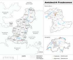
Fraubrunnen District
Fraubrunnen District was one of the 26 administrative districts in the canton of Bern, Switzerland. Its capital was the municipality of Fraubrunnen. The district had an area of 124 km² and consisted of 27 municipalities. It was dissolved on 1 January 2010 as part of a reorganization of the districts of the Canton. Much of the district became part of the new Emmental district.[1]
| Municipality | Population (Jan 2005) | Area (km²) |
|---|---|---|
| Bangerten | 163 | 2.2 |
| Bätterkinden | 2,780 | 10.1 |
| Büren zum Hof | 455 | 3.5 |
| Deisswil bei Münchenbuchsee | 80 | 2.1 |
| Diemerswil | 185 | 2.8 |
| Etzelkofen | 350 | 2.8 |
| Fraubrunnen | 1,691 | 7.7 |
| Grafenried | 912 | 4.7 |
| Iffwil | 399 | 5.0 |
| Jegenstorf | 4,508a | 8.9 |
| Limpach | 327 | 4.4 |
| Mattstetten | 565 | 3.8 |
| Moosseedorf | 3,437 | 6.3 |
| Mülchi | 250 | 3.8 |
| Münchenbuchsee | 9,519 | 8.9 |
| Münchringen | 544 | 2.4 |
| Ruppoldsried | 256 | 2.2 |
| Schalunen | 378 | 1.4 |
| Scheunen | 71 | 2. |
| Urtenen-Schönbühl | 5,337 | 7.2 |
| Utzenstorf | 3,763 | 17.0 |
| Wiggiswil | 95 | 1.4 |
| Wiler bei Utzenstorf | 794 | 3.8 |
| Zauggenried | 314 | 3.7 |
| Zielebach | 337 | 1.9 |
| Zuzwil | 504 | 3.5 |
- ^a Population is as of December 2007, includes population and area of Ballmoos which merged into Jegenstorf in 2010
Fraubrunnen District Amtsbezirk Fraubrunnen | |
|---|---|
District | |
 | |
| Country | |
| Canton | |
| Capital | Fraubrunnen |
| Area | |
| • Total | 124 km2 (48 sq mi) |
| Population (2007) | |
| • Total | 38,895 |
| • Density | 310/km2 (810/sq mi) |
| Time zone | UTC+1 (CET) |
| • Summer (DST) | UTC+2 (CEST) |
| Municipalities | 26 |
References
- Swiss Federal Statistical Office - Amtliches Gemeindeverzeichnis der Schweiz (in German) accessed 18 September 2017
This article is issued from Wikipedia. The text is licensed under Creative Commons - Attribution - Sharealike. Additional terms may apply for the media files.