Fourth Lake (New York)
Fourth Lake is a lake located by Eagle Bay, New York. Fourth Lake is part of the Fulton Chain Lakes. Fish species present in the lake are lake trout, atlantic salmon, landlocked salmon, white sucker, brook trout, rainbow trout, yellow perch, and brown trout. Hard surface ramp on Route 28, 10 miles east of Old Forge and there is a hand launch access on South Shore Road.[3]
_(19177870649).jpg)
Fourth Lake, 1894
| Fourth Lake | |
|---|---|
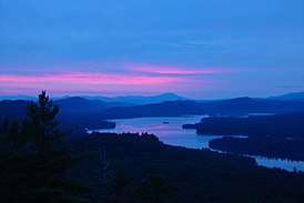 View of Fourth Lake from Bald Mountain | |
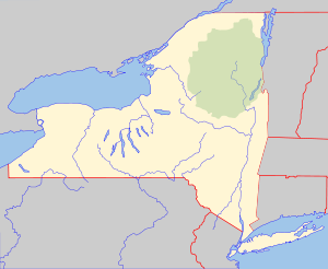 Fourth Lake Location within New York  Fourth Lake Fourth Lake (the United States) | |
| Location | Herkimer County, Hamilton County, New York |
| Coordinates | 43°44′57″N 74°52′23″W, 43°44′32″N 74°53′00″W, 43°45′03″N 74°52′36″W, 43°45′22″N 74°49′19″W[1] |
| Type | Lake |
| Primary inflows | Fifth Lake |
| Primary outflows | Third Lake |
| Basin countries | United States |
| Surface area | 2,138 acres (8.65 km2)[2] |
| Average depth | 34 feet (10 m) |
| Max. depth | 85 feet (26 m) |
| Shore length1 | 9.8 miles (15.8 km) |
| Surface elevation | 1,706 feet (520 m) |
| Islands | 9 |
| Settlements | Eagle Bay, New York |
| 1 Shore length is not a well-defined measure. | |
Tributaries and locations
- Alger Island – Also called Big Island, it is the largest island on the lake. There is a campground on Alger Island.
- Bartons Island – An island located on the north shore of the lake, northwest of Alger Island.
- Cedar Island – An island located southeast of Eagle Point.
- Dollar Island – An island located east of Cedar Island.
- Eagle Bay – A hamlet located on the northeast shore of the lake.
- Eagle Point – A point of the lake located south of Eagle Bay on the north shore.
- Gulf Rock Point – A point of the lake located on the south shore, south of Eagle Bay.
- Quiver Pond – A pond located south of Fourth Lake. The outlet creek flows into Fourth Lake.
- Rock Point – A point of the lake located on the east end of the lake near the boat launch.
- Shelter Island – An island located on the south shore, south of Alger Island. Shelter Island is connected to shore by a man made foot bridge.
- Surprise Pond – A small pond located north of Fourth Lake and west of Eagle Bay.
- Thistle Island – An island located west of Barton's Island. Thistle Island is connected to shore by a man made foot bridge.
gollark: No, not cryptocurrency, just regular fiat currency but with blockchain and cloud.
gollark: No, it will be stored in osmarksbank™ using advanced blockchain and cloud.
gollark: I will use my future vast wealth to set up a charity to promote potatOS use in schools.
gollark: Plus, contingency™.
gollark: You can use stonks™ to get something like ~5%/year average growth.
References
- U.S. Geological Survey Geographic Names Information System: Fourth Lake (New York)
- "fourth lake". dec.ny.gov. nysdec. 1998. Retrieved 9 May 2017.
data
- Sportsman's Connection (Firm) (2004-01-01), Western Adirondacks New York fishing map guide: includes lakes & streams for the following counties: Herkimer, Jefferson, Lewis, Oneida, St. Lawrence., Sportsman's Connection, ISBN 1885010672, OCLC 61449593
This article is issued from Wikipedia. The text is licensed under Creative Commons - Attribution - Sharealike. Additional terms may apply for the media files.