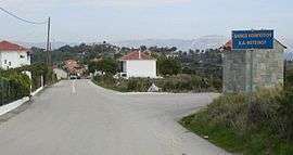
Foteino, Arta
Foteino (Greek: Φωτεινό [![]()
Foteino Φωτεινό | |
|---|---|
 | |
 Foteino | |
| Coordinates: 39°8′4″N 21°6′27″E | |
| Country | Greece |
| Administrative region | Epirus |
| Regional unit | Arta |
| Municipality | Nikolaos Skoufas |
| Municipal unit | Kompoti |
| Elevation | 500 m (1,600 ft) |
| Community | |
| • Population | 178 (2011) |
| • Area (km2) | 8.953 |
| Time zone | UTC+2 (EET) |
| • Summer (DST) | UTC+3 (EEST) |
| Postal code | 471 00 |
| Area code(s) | 26810 |
History
The old name of the village, Hósiana (Greek: Χώσιανα), appears for the first time in 1696, in a historic document in which the villages of Arta asked the Venetian Republic for protection from pirates.[2]
In 1899, a new church was built by destroying a small old one, dating to the early 12th century[3]
The village was constituted as a separate commune with the 186/10.08.1947 government gazette (ΦΕΚ). Until then it was part of the commune of Ano-Petra.[4] With ΦΕΚ 195/23.07.1953, its name changed from Hosiana to Fotino,[5] and with law 2539/1997, as part of the Kapodistrias reforms, the commune became a municipal district of the municipality of Kompoti.
Gallery
 Fotino
 Fotino - Amvrakikos view
 Fotino - Meyarhi View
 Fotino - Peta View - October
 Fotino - Peta View - June
See also
- Kompoti
- Sellades
- Menidi
- Ambracian Gulf
- Ionian Sea
- Arachthos River
External links
Footnotes
- "Απογραφή Πληθυσμού - Κατοικιών 2011. ΜΟΝΙΜΟΣ Πληθυσμός" (in Greek). Hellenic Statistical Authority.
- Kaselouris, Lampros Christos. 1980. Historic And Folklore of Arta. Athens. Page 101
- Kaselouris, Lampros Christos. 1980. Historic And Folklore of Arta. Athens. Page 104
- Kaselouris, Lampros Christos. 1980. Historic And Folklore of Arta. Athens. Page 117
- Kaselouris, Lampros Christos. 1980. Historic And Folklore of Arta. Athens. Page 98