Florida State Road 960
State Road 960 (SR 960), locally known as Northwest 14th Street, is a 0.671-mile-long (1.080 km) east–west street adjacent to Miami International Airport in western Miami-Dade County, Florida. The easternmost segment between the route's eastern terminus and Northwest 37th Avenue is one way westbound. The road runs parallel to the Dolphin Expressway. The designation was created in 2014 as part of a jurisdictional swap over various roadways between the Florida Department of Transportation (FDOT) and the City of Miami.
| ||||
|---|---|---|---|---|
| Northwest 14th Street | ||||
| ||||
| Route information | ||||
| Maintained by FDOT | ||||
| Length | 0.671 mi[1] (1.080 km) | |||
| Existed | 2014–present | |||
| Major junctions | ||||
| East end | ||||
| West end | Northwest 42nd Court in Miami | |||
| Location | ||||
| Counties | Miami-Dade | |||
| Highway system | ||||
| ||||

Route description
.jpg)
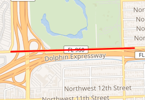
SR 960 begins at the foot of the Dolphin Expressway exit off-ramp serving Northwest 37th Avenue/Douglas Road. Between these two points, the road runs one way westward. SR 960 then passes underneath two overhead exit ramps, one of which serves Miami International Airport from the Dolphin Expressway, and intersects LeJeune Road (SR 953). After passing underneath the Northwest 12th Drive bridge, the route comes to an abrupt end at Northwest 42nd Court.[1][2]
History
SR 960 was created as a condition by FDOT in order to transfer a segment of Brickell Avenue that once carried US Highway 1 (US 1) to the City of Miami.[3][4] In exchange, the city transferred Northwest 14th Street, as well as Northwest 6th Avenue & Northwest 6th Court (SR 925), over to FDOT.[5]
Major intersections
The entire route is in Miami, Miami-Dade County.
| mi[1] | km | Destinations | Notes | ||
|---|---|---|---|---|---|
| 0.000 | 0.000 | East end of westbound traffic and state maintenance at SR 836 off-ramp | |||
| 0.067 | 0.108 | Douglas Road / Northwest 37th Avenue | East end of eastbound traffic | ||
| 0.582 | 0.937 | ||||
| 0.671 | 1.080 | Northwest 42nd Court | West end of state maintenance | ||
| 1.000 mi = 1.609 km; 1.000 km = 0.621 mi | |||||
References
- Florida Department of Transportation. "SR 8960, Miami-Dade County". Straight Line Diagram of Road Inventory. Florida Department of Transportation. Sheet 1. Retrieved September 5, 2016.
- Google (September 5, 2016). "Overview Map of State Road 960 (Northwest 14th Street)" (Map). Google Maps. Google. Retrieved September 5, 2016.
- City of Miami (May 14, 2013). "Resolution File Number 13-00581" (PDF). City of Miami. Retrieved September 5, 2016.
- Special Committee on U.S. Route Numbering (October 28, 2013). "Special Committee on US Route Numbering Meeting Minutes for October 17, 2013 and Report to SCOH October 18, 2013" (PDF) (Report). Washington, DC: American Association of State Highway and Transportation Officials. Archived (PDF) from the original on June 3, 2019. Retrieved September 5, 2016.
- Robbins, John Charles (May 14, 2014). "A Year Later, Brickell Swap Rolling". Miami Today. Retrieved September 5, 2016.
External links
