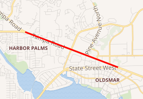
Florida State Road 584
State Road 584 (SR 584), locally known as Tampa Road, is a two-mile-long street connecting Curlew Road (SR 586) and SR 580 in Oldsmar, Florida. A western continuation along Tampa Road (along current CR 752, formerly a section of SR 584) extends six miles (10 km) until its intersection with Alternate US 19-SR 595 near Ozona and one mile (1.6 km) north of Dunedin. At the eastern terminus of SR 584, Tampa Road becomes SR 580 and Hillsborough Avenue, a major highway serving Tampa International Airport in Hillsborough County.
| ||||
|---|---|---|---|---|
| Tampa Road | ||||

| ||||
| Route information | ||||
| Maintained by FDOT | ||||
| Length | 2.135 mi[1] (3.436 km) | |||
| Major junctions | ||||
| West end | ||||
| East end | ||||
| Location | ||||
| Counties | Pinellas | |||
| Highway system | ||||
| ||||
Route description
SR 584 begins at an intersection with SR 586 and CR 752 in Oldsmar, heading southeast as Tampa Road, a six-lane divided highway. CR 752 continues northwest on Tampa Road past this intersection. From the western terminus, the road passes through a mix of residential areas and businesses, crossing CR 667. SR 584 continues past more development before it crosses a CSX railroad line and ends at SR 580. Past this intersection, SR 580 continues along Tampa Road.[1][2]
Major intersections
The entire route is in Oldsmar, Pinellas County.
| mi[1] | km | Destinations | Notes | ||
|---|---|---|---|---|---|
| 0.000 | 0.000 | Western terminus | |||
| 1.068 | 1.719 | ||||
| 2.135 | 3.436 | Eastern terminus | |||
| 1.000 mi = 1.609 km; 1.000 km = 0.621 mi | |||||
References
- FDOT straight line diagrams Archived March 6, 2014, at the Wayback Machine, accessed March 2014
- Google (December 31, 2013). "overview of State Road 584" (Map). Google Maps. Google. Retrieved December 31, 2013.
