Florida State Road 546
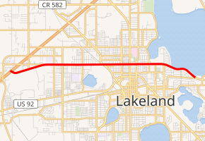
State Road 546 (SR 546) is a 5.837-mile-long (9.394 km) state highway in Lakeland, Polk County, Florida, that runs from Interstate 4 (I-4) to U.S. Route 92 (US 92) and SR 600. SR 546 is only signed for the first 1.731 miles (2.786 km), after which it is concurrent with US 92.
| ||||
|---|---|---|---|---|
| Memorial Boulevard | ||||
| ||||
| Route information | ||||
| Maintained by FDOT | ||||
| Length | 5.837 mi[1] (9.394 km) | |||
| Major junctions | ||||
| West end | ||||
| East end | ||||
| Location | ||||
| Counties | Polk | |||
| Highway system | ||||
| ||||

Major intersections
The entire route is in Lakeland, Polk County.
| mi[1] | km | Destinations | Notes | ||||
|---|---|---|---|---|---|---|---|
| 0.000 | 0.000 | Western terminus | |||||
| 1.731 | 2.786 | West end of US 92 overlap | |||||
| see US 92 (mile 54.247-58.298) | |||||||
| 5.837 | 9.394 | Eastern terminus; east end of US 92 overlap | |||||
| 1.000 mi = 1.609 km; 1.000 km = 0.621 mi | |||||||
gollark: You see, windows bad.
gollark: It asks you to?
gollark: <@!151391317740486657> It actually is.
gollark: !faq pastebin:potatos
gollark: They run outside of the sandbox.
References
External links
This article is issued from Wikipedia. The text is licensed under Creative Commons - Attribution - Sharealike. Additional terms may apply for the media files.