Florida State Road 406
State Road 406 (SR 406), also known as Garden Street, is an east–west road in northern Titusville that connects Interstate 95 (I-95 or SR 9) to U.S. Route 1 (US 1 or SR 5). West of I-95, Garden Street is unsigned County Road 406 (CR 406), with its western terminus at Carpenter Road. East of US 1, it becomes A. Max Brewer Memorial Parkway, part of the Indian River Lagoon Scenic Highway.
| ||||
|---|---|---|---|---|
| Garden Street | ||||
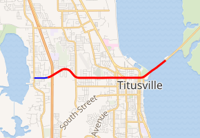
SR 406 in red, CR 406 in blue | ||||
| Route information | ||||
| Maintained by FDOT | ||||
| Length | 2.949 mi[1] (4.746 km) | |||
| Existed | 1945–present | |||
| Major junctions | ||||
| West end | ||||
| East end | ||||
| Location | ||||
| Counties | Brevard | |||
| Highway system | ||||
| ||||
Major intersections
The entire route is in Titusville, Brevard County.
| mi[1] | km | Destinations | Notes | ||
|---|---|---|---|---|---|
| 0.000 | 0.000 | west end of state maintenance | |||
| 0.15 | 0.24 | I-95 exit 220 | |||
| 2.285 | 3.677 | Park Avenue (CR 405) | |||
| 2.903 | 4.672 | ||||
| 2.949 | 4.746 | ||||
| 3.281– 3.890 | 5.280– 6.260 | A. Max Brewer Bridge over Indian River (Atlantic Intracoastal Waterway) | |||
| 4.683 | 7.537 | Merritt Island National Wildlife Refuge | |||
| 1.000 mi = 1.609 km; 1.000 km = 0.621 mi | |||||
gollark: Hey, I could implement that in potatOS.
gollark: ̣̣̣
gollark: I mean, Switchcraft has one if I remember right...
gollark: You don't HAVE to have them because everyone else does.
gollark: I find anti-advertising rules beyond just normal anti-spam stuff kind of anticompetitive, honestly.
References
- FDOT straight line diagrams Archived March 6, 2014, at the Wayback Machine, accessed March 2014
External links
This article is issued from Wikipedia. The text is licensed under Creative Commons - Attribution - Sharealike. Additional terms may apply for the media files.