Flats Industrial Railroad
The Flats Industrial Railroad (reporting mark FIR) is a Class III railroad that provides short-line commercial/industrial switching service in Cleveland, Cuyahoga County, Ohio, primarily with CSX Transportation and the Norfolk Southern Railway.
| Overview | |
|---|---|
| Headquarters | 1757 Columbus Road, Cleveland, Cuyahoga County, Ohio 44113 |
| Reporting mark | FIR |
| Locale | Cleveland, Cuyahoga County, Ohio |
| Dates of operation | 1996[1]– |
| Predecessor | Conrail[1] |
| Technical | |
| Track gauge | 4 ft 8 1⁄2 in (1,435 mm) standard gauge |
| Length | 4 miles (6 km)[1][2] |
History
Trains have run in the Cuyahoga Valley since the 1880s. In 1880, the Valley Railway began operations, transporting coal to Cleveland, Akron, and Canton from the Tuscarawas River Valley and providing passenger service along the way. After a decade of operation, the Valley Railway became part of the Baltimore & Ohio Railroad. In the 20th century, competition from automobiles, trucks, and buses caused the decline of both freight and passenger service.
Right-of-way ownership shifted over the years from Valley Railway to the Cleveland Terminal & Valley Railway (CT&V), to the Baltimore and Ohio Railroad, to the Chessie System.
Today
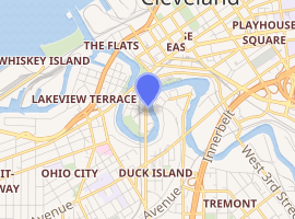
Flats Industrial Railroad acquired its rails and right-of-way within the Flats District (Cleveland) from former Conrail. As of 2009, the Class III Short Line railroad operates as the Flats Industrial Railroad Company (FIR/FIRS). . The railroad operates on weekdays, reportedly around 7:00 to 10:00AM in the morning. At one time, they used to have a sand trans-loading business to keep themselves busy while not switching at Cleveland's Cereal Food Processors elevator. They also used to serve fatty oils and synthetic esters producer, "Werner G. Smith." They interchange with the Norfolk Southern in a yard between Fulton Road and W.41 Street in Cleveland, Ohio. The Cloggsville Line, operated by Norfolk Southern, serves that yard. Company (FIR/FIRS).
As recently as 2014, FIR had only two employees.[3]
Equipment
Flats Industrial Railroad initially operated one switching locomotive, later adding a second locomotive.[B]
Images and media
Facilities
Flats Industrial Railroad vertical lift bridge | |
|---|---|
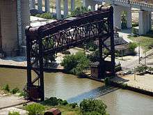 Flats Industrial Railroad vertical lift bridge | |
| Coordinates | 41°29′31.5″N 81°41′59.25″W |
| Carries | Flats Industrial Railroad |
| Crosses | Cuyahoga River |
| Locale | Cleveland, Cuyahoga County, Ohio |
| Maintained by | Flats Industrial Railroad |
| Characteristics | |
| Design | Metal Riveted Warren Through Truss, Stationary, Vertical lift bridge |
| Material | Steel |
| Total length | 260 feet (79.2 m) |
| Longest span | 260 feet (79.2 m) |
| No. of spans | 1 |
| Piers in water | 0 |
| History | |
| Opened | 1953 |
| |
All locations are in Cleveland, Cuyahoga County, Ohio:
| (former) ConRail/PennCentral Clark branch and DK yard | |
|---|---|
| Overview | |
| Type | Industrial Freight Short-line railroad |
| System | Flats Industrial Railroad |
| Locale | Cleveland, Cuyahoga County, Ohio |
| Termini | CP Knob switch connection with CSX/NS 1. Train Avenue and Willey Road 2. Carter and Scranton road 3. Carter and Old River road 4. FIR siding, Fall and French street 5. FIR siding, Fall and French street 6. FIR siding, Fall and French street 7. flour mill, Merwin street 8. flour mill, Merwin street 9. flour mill, Cuyahoga River 10. flour mill, Cuyahoga River |
| Operation | |
| Opened | 1996 |
| Owner | Flats Industrial Railroad |
| Operator(s) | Flats Industrial Railroad |
| Character | Class III railroad |
| Technical | |
| Line length | 4 miles (6.4 km)[1] |
| Track length | 4 miles (6.4 km)[1] |
| Number of tracks | 1 to 3 |
| Track gauge | 4 ft 8 1⁄2 in (1,435 mm) standard gauge |
| Highest elevation | 571 feet (174.0 m) |
Flats Industrial Railroad | |||||||||||||||||||||||||||||||||||||||||||||||||||||||||||||||||||||||||||||||||||||||||||||||||||||||||||||||||||||||||||||||||||||||||||||||||||||||||||||||||||||||||||||||||||||||||||||||||||||||||||||||||||||||||||||||||||||||||||||||||||||||||||||||||||||||||||||||||||||||||||||||||||||||||||||||||||||||||||||||||||||||||||||||||||||||||||||||||||||||||||||||||||||||||||||||||||||||||||||||||||||||||||||
|---|---|---|---|---|---|---|---|---|---|---|---|---|---|---|---|---|---|---|---|---|---|---|---|---|---|---|---|---|---|---|---|---|---|---|---|---|---|---|---|---|---|---|---|---|---|---|---|---|---|---|---|---|---|---|---|---|---|---|---|---|---|---|---|---|---|---|---|---|---|---|---|---|---|---|---|---|---|---|---|---|---|---|---|---|---|---|---|---|---|---|---|---|---|---|---|---|---|---|---|---|---|---|---|---|---|---|---|---|---|---|---|---|---|---|---|---|---|---|---|---|---|---|---|---|---|---|---|---|---|---|---|---|---|---|---|---|---|---|---|---|---|---|---|---|---|---|---|---|---|---|---|---|---|---|---|---|---|---|---|---|---|---|---|---|---|---|---|---|---|---|---|---|---|---|---|---|---|---|---|---|---|---|---|---|---|---|---|---|---|---|---|---|---|---|---|---|---|---|---|---|---|---|---|---|---|---|---|---|---|---|---|---|---|---|---|---|---|---|---|---|---|---|---|---|---|---|---|---|---|---|---|---|---|---|---|---|---|---|---|---|---|---|---|---|---|---|---|---|---|---|---|---|---|---|---|---|---|---|---|---|---|---|---|---|---|---|---|---|---|---|---|---|---|---|---|---|---|---|---|---|---|---|---|---|---|---|---|---|---|---|---|---|---|---|---|---|---|---|---|---|---|---|---|---|---|---|---|---|---|---|---|---|---|---|---|---|---|---|---|---|---|---|---|---|---|---|---|---|---|---|---|---|---|---|---|---|---|---|---|---|---|---|---|---|---|---|---|---|---|---|---|---|---|---|---|---|---|---|---|---|---|---|---|---|---|---|---|---|---|---|---|---|---|---|---|---|---|---|---|---|---|---|---|---|---|---|---|---|---|---|---|---|---|---|---|---|---|---|---|---|---|---|---|---|---|---|---|---|---|---|---|---|---|
| |||||||||||||||||||||||||||||||||||||||||||||||||||||||||||||||||||||||||||||||||||||||||||||||||||||||||||||||||||||||||||||||||||||||||||||||||||||||||||||||||||||||||||||||||||||||||||||||||||||||||||||||||||||||||||||||||||||||||||||||||||||||||||||||||||||||||||||||||||||||||||||||||||||||||||||||||||||||||||||||||||||||||||||||||||||||||||||||||||||||||||||||||||||||||||||||||||||||||||||||||||||||||||||
| |||||||||||||||||||||||||||||||||||||||||||||||||||||||||||||||||||||||||||||||||||||||||||||||||||||||||||||||||||||||||||||||||||||||||||||||||||||||||||||||||||||||||||||||||||||||||||||||||||||||||||||||||||||||||||||||||||||||||||||||||||||||||||||||||||||||||||||||||||||||||||||||||||||||||||||||||||||||||||||||||||||||||||||||||||||||||||||||||||||||||||||||||||||||||||||||||||||||||||||||||||||||||||||
Cleveland Union Terminal Branch | |||||||||||||||||||||||||||||||||||||||||||||||||||||||||||||||||||||||||||||||||||||||||||||||||||||||||||||||||||||||||||||||||||||||||||||||||||||||||||||||||||||||||||||||||||||||||||||||||||||||||||||||||||||||||||||||||||||||||||||||||||||||||||||||||||||||||||||||||||||||||||||||||||||||||||||||||||||||||||||||||||||||||||||||||||||||||||||||||||||||||||||||||||||||||||||||||||||||||||||||||||||||||||||||||||||||||||||||||||||||||||||||||||||||||||||||||||||||||||||||||||||||||||||||||||||||||||||||||||||||||||||||||||||||||||||||||||||||||||||||||||||||||||||||||||||||||||||||||||
|---|---|---|---|---|---|---|---|---|---|---|---|---|---|---|---|---|---|---|---|---|---|---|---|---|---|---|---|---|---|---|---|---|---|---|---|---|---|---|---|---|---|---|---|---|---|---|---|---|---|---|---|---|---|---|---|---|---|---|---|---|---|---|---|---|---|---|---|---|---|---|---|---|---|---|---|---|---|---|---|---|---|---|---|---|---|---|---|---|---|---|---|---|---|---|---|---|---|---|---|---|---|---|---|---|---|---|---|---|---|---|---|---|---|---|---|---|---|---|---|---|---|---|---|---|---|---|---|---|---|---|---|---|---|---|---|---|---|---|---|---|---|---|---|---|---|---|---|---|---|---|---|---|---|---|---|---|---|---|---|---|---|---|---|---|---|---|---|---|---|---|---|---|---|---|---|---|---|---|---|---|---|---|---|---|---|---|---|---|---|---|---|---|---|---|---|---|---|---|---|---|---|---|---|---|---|---|---|---|---|---|---|---|---|---|---|---|---|---|---|---|---|---|---|---|---|---|---|---|---|---|---|---|---|---|---|---|---|---|---|---|---|---|---|---|---|---|---|---|---|---|---|---|---|---|---|---|---|---|---|---|---|---|---|---|---|---|---|---|---|---|---|---|---|---|---|---|---|---|---|---|---|---|---|---|---|---|---|---|---|---|---|---|---|---|---|---|---|---|---|---|---|---|---|---|---|---|---|---|---|---|---|---|---|---|---|---|---|---|---|---|---|---|---|---|---|---|---|---|---|---|---|---|---|---|---|---|---|---|---|---|---|---|---|---|---|---|---|---|---|---|---|---|---|---|---|---|---|---|---|---|---|---|---|---|---|---|---|---|---|---|---|---|---|---|---|---|---|---|---|---|---|---|---|---|---|---|---|---|---|---|---|---|---|---|---|---|---|---|---|---|---|---|---|---|---|---|---|---|---|---|---|---|---|---|---|---|---|---|---|---|---|---|---|---|---|---|---|---|---|---|---|---|---|---|---|---|---|---|---|---|---|---|---|---|---|---|---|---|---|---|---|---|---|---|---|---|---|---|---|---|---|---|---|---|---|---|---|---|---|---|---|---|---|---|---|---|---|---|---|---|---|---|---|---|---|---|---|---|---|---|---|---|---|---|---|---|---|---|---|---|---|---|---|---|---|---|---|---|---|---|---|---|---|---|---|---|---|---|---|---|---|---|---|---|---|---|---|---|---|---|---|---|---|---|---|---|---|---|---|---|---|---|---|---|---|---|---|---|---|---|---|---|---|---|---|---|---|---|---|---|---|---|---|---|---|---|---|---|---|---|---|---|---|---|---|---|---|---|---|---|---|---|---|---|---|---|---|---|---|---|---|---|---|---|---|
| |||||||||||||||||||||||||||||||||||||||||||||||||||||||||||||||||||||||||||||||||||||||||||||||||||||||||||||||||||||||||||||||||||||||||||||||||||||||||||||||||||||||||||||||||||||||||||||||||||||||||||||||||||||||||||||||||||||||||||||||||||||||||||||||||||||||||||||||||||||||||||||||||||||||||||||||||||||||||||||||||||||||||||||||||||||||||||||||||||||||||||||||||||||||||||||||||||||||||||||||||||||||||||||||||||||||||||||||||||||||||||||||||||||||||||||||||||||||||||||||||||||||||||||||||||||||||||||||||||||||||||||||||||||||||||||||||||||||||||||||||||||||||||||||||||||||||||||||||||
| |||||||||||||||||||||||||||||||||||||||||||||||||||||||||||||||||||||||||||||||||||||||||||||||||||||||||||||||||||||||||||||||||||||||||||||||||||||||||||||||||||||||||||||||||||||||||||||||||||||||||||||||||||||||||||||||||||||||||||||||||||||||||||||||||||||||||||||||||||||||||||||||||||||||||||||||||||||||||||||||||||||||||||||||||||||||||||||||||||||||||||||||||||||||||||||||||||||||||||||||||||||||||||||||||||||||||||||||||||||||||||||||||||||||||||||||||||||||||||||||||||||||||||||||||||||||||||||||||||||||||||||||||||||||||||||||||||||||||||||||||||||||||||||||||||||||||||||||||||
| Coordinates |
Name [A] |
Type |
Address |
Description |
|---|---|---|---|---|
| 41°29′30.75″N 81°42′0.5″W | Head | Quarters | 1757 Columbus Road, 44113 | |
| 41°29′31.5″N 81°41′59.25″W | Vertical Lift | bridge | over Cuyahoga River | |
| 41°29′31″N 81°42′1″W | Locomotive | parking | 1757 Columbus Road, 44113 | model ? |
| 41°29′30.75″N 81°42′1.25″W | W | Switch | 1757 Columbus Road, 44113 | |
| 41°29′27″N 81°41′45″W | E | Switch | Carter Road, Scranton Road | |
| 41°29′25.5″N 81°41′44.25″W | EE | Switch | Carter Road, Scranton Road | |
| 41°29′20.25″N 81°41′42.75″W | EEE | Switch | Lorain-Carnegie, Scranton Road | |
| 41°29′25.5″N 81°41′43.75″W | EEEN | Switch | Carter Road, Scranton Road | |
| 41°29′28.75″N 81°41′45″W | EEENW | EOL | Carter Road and Old River Road | ruins to former Old River Road rail lift bridge and GCRTA W.10th tracks |
| 41°29′34.5″N 81°41′42.75″W | EEENE | EOL | Carter Road and Scranton Road | rear of Carter and Scranton Road businesses |
| 41°29′15.25″N 81°41′42.25″W | ES | Switch | Scranton Road, University Road | |
| 41°29′13″N 81°41′41.75″W | ESS | Switch | Scranton Road and University Road | |
| 41°29′3.5″N 81°41′45.25″W | ESSS | Switch | Scranton Road, Abbey Avenue | |
| 41°28′53.25″N 81°41′52″W | ESSSE | EOL | Willey Road, Train Avenue | |
| 41°28′53″N 81°41′53″W | Willey | Switch | Willey Road, Train Avenue | |
| 41°28′37.75″N 81°42′13″W | ESSSS | Switch | Train Avenue, West 30th. Street | |
| 41°28′37″N 81°42′14.5″W | ESSSSN | Switch | Train Avenue, Richner Avenue | |
| 41°28′26″N 81°42′42.25″W | ESSSSNS | Switch | Train Avenue and Richner Avenue | |
| 41°28′25.25″N 81°42′44.25″W | ESSSSS | Switch | Train Avenue and Richner Avenue | |
| 41°28′23.5″N 81°42′47.75″W | ESSSSSM | Switch | Train Avenue, Richner Avenue | CP Knob connection to (NS/NSR?) main line |
| 41°29′32″N 81°42′5.75″W | WN | Switch | Fall Street and Leonard Street | |
| 41°29′33.5″N 81°42′8″W | WNN | Switch | Fall Street and Leonard Street | |
| 41°29′35.5″N 81°42′12.5″W | WNNN | EOL | Cuyahoga River | flour mill |
| 41°29′35.25″N 81°42′12.5″W | WNNS | EOL | Cuyahoga River | flour mill |
| 41°29′32.75″N 81°42′9.25″W | WNS | Switch | Fall Street | |
| 41°29′33.25″N 81°42′11″W | WNSN | EOL | Merwin Street | flour mill |
| 41°29′33″N 81°42′11″W | WNSS | EOL | Merwin Street | flour mill |
| 41°29′29.75″N 81°42′3.75″W | WS | Switch | French Street and Columbus Road | |
| 41°29′29.25″N 81°42′5.5″W | WSN | Switch | Fall Street and French Street | |
| 41°29′27″N 81°42′8.5″W | WSNN | EOL | Fall Street and French Street | FIR siding |
| 41°29′26.75″N 81°42′8.5″W | WSNS | EOL | Fall Street and French Street | FIR siding |
| 41°29′27.25″N 81°42′7.25″W | WSS | EOL | Fall Street and French Street | ? spare parts locomotive ? |
Accidents
In 2005, FIR reported a single Highway-Rail Crossing incident, no other accidents, and no one killed or injured.[4] In 2004, FIR did not report any accidents (train, highway-rail crossing, other incidents).[5]
See also
- Cleveland railroad history
- List of crossings of the Cuyahoga River
- List of Ohio railroads
- Connecting or neighboring railroads:
- Cleveland Commercial Railroad
- CSX Transportation
- Cuyahoga Valley Scenic Railroad
- Cleveland Works Railway
- Norfolk Southern Corporation
- Newburgh and South Shore Railroad
- Wheeling and Lake Erie Railway
Notes
^ A: Switch names are HQ-relative, should be Main-line relative.
^ B: Both locomotives are visible on Google Earth and Maps imagery, there are many (copyrighted) pictures of each posted on other web sites.
^ C: CP as in CP Knob refers to "control point". FIR operates on what used to be the Clark Branch and the DK Yard. The other bridge across the Cuyahoga River (OX/Flats Tower/Carter-Old River) in no longer used. FIR's interchange connection at CP Knob is to the CUT branch/main line.[6]
^ D: Department of Transportation, Surface Transportation Board, STB Finance Docket No. 33044
Flats Industrial Railroad Company--Acquisition and Operation Exemption--Consolidated Rail Corporation
Flats Industrial Railroad Company, a noncarrier, has filed a verified notice of exemption under 49 CFR 1150.31 to acquire by purchase, and to operate, approximately 4 miles (6 km) of rail lines owned by Consolidated Rail Corporation between M.P. 14 at Cleveland, Cuyahoga County, OH, and M.P. 10 at Carter Road, Cuyahoga County, OH, including the industrial lead to Cereal Food Processors, Inc. The proposed transaction was to have been consummated on or after October 1, 1996.
Decided: October 3, 1996.[7]
References
- "Vol. 66, No. 221/Thursday, November 15, 2001/Notices STB Finance Docket No. 34108". Federal Register. Archived from the original (PDF) on 2011-05-20.
- "Table 1-13: Freight Railroads Operating in Ohio by Class: 2000". Bureau of Transportation Statistics. Archived from the original on 2008-10-11. Retrieved 2008-06-25.
- "TOTAL EMPLOYMENT BY STATE AND LAST RAILROAD EMPLOYER - CALENDAR YEAR 2014" (PDF). Railroad Retirement Board. Archived from the original (PDF) on 2016-08-12. Retrieved 2016-06-18.
- "Railroad Safety Statistics 2005 Annual Report" (PDF). Federal Railroad Administration, United States Department of Transportation. Retrieved 2008-07-28.
- "Railroad Safety Statistics 2004 Annual Report" (PDF). Federal Railroad Administration, United States Department of Transportation. Archived from the original (PDF) on 2008-04-22. Retrieved 2008-07-28.
- "Lake Region - Cleveland Division Lakefront". Penn Central Railroad Online. Retrieved 2008-07-19.
- "DoT Report #21 - October, 1996". TrainNet.Org, Federal Register, Surface Transportation Board, United States Department of Transportation. Archived from the original on 2008-08-29. Retrieved 2008-07-19.
General References
- Ohio Department of Transportation
- "RAILROADS IN OHIO". Ohio Department of Transportation. Archived from the original on 2008-02-29.
- "OHIO RAILROADS EMERGENCY CONTACT LIST CODE" (PDF). Ohio Department of Transportation.
- "Railroads". Public Utilities Commission of Ohio. Retrieved 2008-07-19.
- "Short Line Details - 519 Flats Industrial Railroad Co". Norfolk Southern Railway. Retrieved 2008-07-19.