Firth of Forth Banks Complex
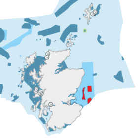
The name Firth of Forth Banks Complex refers to a complex of sand and gravel sea banks in the North Sea, lying at the mouth of the Firth of Forth in the seas off the east coast of Scotland. From south to north the banks are named the Berwick Bank, the Scalp Bank, the Wee Bankie and the Montrose Bank.[2] Since 2014 the banks have been protected as a single Nature Conservation Marine Protected Area, which comprises three discrete zones covering a total area of 213,000 hectares (2,130 km2) of Scottish Offshore Waters.[1]
| Firth of Forth Banks Complex MPA | |
|---|---|
 Firth of Forth Banks MPA shown in red, in Scottish Waters | |
| Location | North Sea, Scotland |
| Coordinates | 56°23′N 1°37′W |
| Area | 2,130 km2 (820 sq mi)[1] |
| Designation | Scottish Government |
| Established | 2014 |
| Operator | Marine Scotland |
The seabed of the banks is formed of many different types of sands and gravels, and is highly influenced by the strong currents at the mouth of the Firth of Forth. This creates a highly productive habitat, which supports a rich array of sea creatures including crabs, starfish, flatfish, seals and dolphins; the Berwick Bank in particular is noted as an important spawning ground for plaice. The sand and gravel of the banks also support ocean quahog, a large and slow growing clam which have a lifespan of more than 400 years and are thus considered to be amongst the oldest living animals on Earth.[2][3]
The richness of the seas here means that the banks are also important for seabirds nesting on the east coast of Scotland, which regularly visit the area to feed.[2][3]
References
- "SiteLink: Firth of Forth Banks Complex MPA(NC)". Scottish Natural Heritage. Retrieved 22 October 2019.
- "Firth of Forth Banks Complex Marine Protected Area (MPA)" (PDF). Joint Nature Conservation Committee. Retrieved 22 October 2019.
- "Firth of Forth Banks Complex Marine Protected Area NCMPA". Marine Conservation Society. Retrieved 22 October 2019.