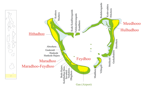
Feydhoo (Seenu Atoll)
Feydhoo (Dhivehi: ފޭދޫ) is one of the inhabited islands of the Addu Atoll (formerly known as Seenu Atoll).
Feydhoo މަރަދޫފޭދޫ | |
|---|---|
 Feydhoo Location in Addu Atoll  Feydhoo Feydhoo (Maldives) | |
| Coordinates: 00°40′57″S 73°08′07″E | |
| Country | Maldives |
| Geographic atoll | Addu Atoll |
| Administrative atoll | Seenu Atoll |
| Distance to Malé | 538.76 km (334.77 mi) |
| Government | |
| • Island Chief | Hassan Latheef |
| Area | |
| • Total | 1.22 km2 (0.47 sq mi) |
| Population (2014)[1] | |
| • Total | 3,431 (including foreigners) |
| Time zone | UTC+05:00 (MST) |
The people of Feydhoo are former residents of Gan. Gan was a very fertile island with its coconut palms, breadfruit trees, yam, binbi and numerous other types of trees flourishing. Even during the Second World War, the people of Gan were economically self-sufficient. However, in 1956/1957 they had to leave their livelihood they had been enjoying for so long, forever because the British Royal Air Force leased the island to build RAF Gan, a military base on the island. All the residents were moved to the next island west of Gan, Feydhoo, a less fertile and much smaller island whose own residents were moved to the eastern side of Maradhoo.
In 2013, the districts of Feydhoo and Maradhoo-Feydhoo were united to one district.
Geography
It is the southernmost inhabited island of Maldives. The island is 538.76 km (335 mi; 291 nmi) south of the country's capital, Malé.[2]
Demography
| Year | Pop. | ±% |
|---|---|---|
| 2006 | 2,724 | — |
| 2014 | 3,193 | +17.2% |
| 2006-2014: Census populations Source: [3] | ||
References
- "Table PP5: Resident Population by sex, nationality and locality (administrative islands), 2014" (PDF). Population and Households Census 2014. National Bureau of Statistics. p. 35. Retrieved 7 August 2018.
- "Coordinate Distance Calculator". Boulter.com. Retrieved 7 August 2018.
- "Table 3.3: Total Maldivian Population by Islands" (PDF). National Bureau of Statistics. Retrieved 7 August 2018.