Fertőszentmiklós
Fertőszentmiklós is a small town in Győr-Moson-Sopron county, Hungary.
Fertőszentmiklós | |
|---|---|
 Flag 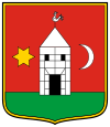 Coat of arms | |
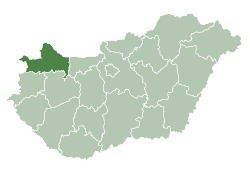
 Fertőszentmiklós Location of Fertőszentmiklós | |
| Coordinates: 47.58533°N 16.87052°E | |
| Country | |
| County | Győr-Moson-Sopron |
| District | Sopron |
| Area | |
| • Total | 39.39 km2 (15.21 sq mi) |
| Population (2015)[1] | |
| • Total | 3,854 |
| • Density | 98/km2 (250/sq mi) |
| Time zone | UTC+1 (CET) |
| • Summer (DST) | UTC+2 (CEST) |
| Postal code | 9444 |
| Area code | (+36) 99 |
| Website | www |
Location
Fertőszentmiklós is located on the Small Plain and it is part of the Transdanubian region. It has a population of 3854 people (2015). Fertőszentmiklós is very well situated because it's close to the Hungarian-Austrian border. The name of the town comes from the fusion of two smaller villages: Szentmiklós and Szerdahely. So they called the new village Fertőszentmiklós.
Twin towns — sister cities
Fertőszentmiklós is twinned with:

gollark: Obviously #10 was palaiologos.
gollark: We collaborated on it.
gollark: Obviously that was me.
gollark: Well, one test case.
gollark: #9 seems fine, I ran some test cases on it.
References
- Gazetteer of Hungary, 1st January 2015. Hungarian Central Statistical Office.
External links
| Wikimedia Commons has media related to Fertőszentmiklós. |
- Official website in Hungarian
- Street map (in Hungarian)
- http://www.nemzetijelkepek.hu/onkormanyzat-fertoszentmiklos_en.shtml
| City with county rights (1) |
| |
|---|---|---|
| Towns (2) | ||
| Large village (1) | ||
| Villages (35) |
| |
This article is issued from Wikipedia. The text is licensed under Creative Commons - Attribution - Sharealike. Additional terms may apply for the media files.