Faya-Largeau
Faya-Largeau[2] (also known as Faya,[3] Arabic: فايا لارجو or فايا) is the largest city in northern Chad and was the capital of the region of Bourkou-Ennedi-Tibesti.[4] It is now in the Borkou Region, which was formed in 2008 from the Borkou Department of the former Bourkou-Ennedi-Tibesti region.
Faya-Largeau فايا لارجو | |
|---|---|
 A Chadian soldier part of an exercise near Faya-Largeau | |
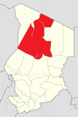
 Faya-Largeau Location in Chad (Borkou Region highlighted) | |
| Coordinates: 17°55′01″N 19°7′0″E | |
| Country | |
| Region | Borkou (since 2008) |
| Department | Borkou |
| Sub-Prefecture | Faya-Largeau |
| Elevation | 245 m (804 ft) |
| Population (2012)[1] | |
| • Total | 48,090 |
| Time zone | +1 |
History

Originally called Faya, the town was renamed Largeau after French Colonel Étienne Largeau;[3] upon Chadian independence from France, it assumed the name Faya-Largeau. The town was captured by Libya when Libya annexed the Aouzou Strip in 1975, but was retaken by Hissène Habré's forces in 1980.[5] Libya recaptured Faya-Largeau in 1983, but retreated in 1987.[5]
Economy
Due to the considerable underground water supply in the town, the main industry is agriculture, while three lakes lie immediately north of Faya-Largeau. The town is serviced by Faya-Largeau Airport (IATA: FYT, ICAO: FTTY)[6] with a paved runway.
Demographics
| Year | Population[7] |
|---|---|
| 1993 | 9,867 |
| 2008 | 14,123 |
Climate
Faya-Largeau has a subtropical hot desert climate typical of the Borkou Region lying on the heart of the Sahara Desert. Average maximum temperatures in Faya-Largeau are consistently over 39 °C (102 °F) from April to September, reaching a maximum of 42.1 °C (107.8 °F) in June. The coolest months are December and January with an average maximum temperature of 26.4 °C (79.5 °F). Annual precipitation averages only 11.7 millimetres (0.46 in) and generally only occurs from June to September, although some years have no rainfall at all. The sunshine duration is one of the highest found in the world with some 3,800 hours of bright sunshine annually, and every month receives an average sunshine duration above 290 hours.[8][9][10]
| Climate data for Faya-Largeau (1961–1990) | |||||||||||||
|---|---|---|---|---|---|---|---|---|---|---|---|---|---|
| Month | Jan | Feb | Mar | Apr | May | Jun | Jul | Aug | Sep | Oct | Nov | Dec | Year |
| Record high °C (°F) | 39 (102) |
43 (109) |
44 (111) |
49 (120) |
49 (120) |
49 (120) |
47 (117) |
46 (115) |
46 (115) |
47 (117) |
39 (102) |
36 (97) |
49 (120) |
| Average high °C (°F) | 26.4 (79.5) |
29.4 (84.9) |
33.6 (92.5) |
39.1 (102.4) |
41.0 (105.8) |
42.1 (107.8) |
41.0 (105.8) |
40.2 (104.4) |
39.8 (103.6) |
36.5 (97.7) |
31.1 (88.0) |
27.6 (81.7) |
35.7 (96.3) |
| Daily mean °C (°F) | 20.0 (68.0) |
22.2 (72.0) |
26.0 (78.8) |
30.8 (87.4) |
33.0 (91.4) |
34.1 (93.4) |
33.4 (92.1) |
33.1 (91.6) |
32.7 (90.9) |
29.5 (85.1) |
24.5 (76.1) |
21.0 (69.8) |
28.4 (83.1) |
| Average low °C (°F) | 13.6 (56.5) |
15.0 (59.0) |
18.4 (65.1) |
22.4 (72.3) |
25.0 (77.0) |
26.1 (79.0) |
25.8 (78.4) |
26.0 (78.8) |
25.9 (78.6) |
22.5 (72.5) |
17.9 (64.2) |
14.4 (57.9) |
21.1 (70.0) |
| Record low °C (°F) | 4 (39) |
7 (45) |
11 (52) |
14 (57) |
17 (63) |
17 (63) |
16 (61) |
16 (61) |
17 (63) |
12 (54) |
9 (48) |
3 (37) |
3 (37) |
| Average precipitation mm (inches) | 0.0 (0.0) |
0.0 (0.0) |
0.0 (0.0) |
0.1 (0.00) |
0.4 (0.02) |
0.3 (0.01) |
3.0 (0.12) |
7.0 (0.28) |
0.8 (0.03) |
0.1 (0.00) |
0.0 (0.0) |
0.0 (0.0) |
11.7 (0.46) |
| Average precipitation days (≥ 0.1 mm) | 0 | 0 | 0 | 1 | 1 | 1 | 2 | 3 | 1 | 1 | 0 | 0 | 10 |
| Average relative humidity (%) | 25 | 20 | 18 | 18 | 17 | 20 | 27 | 33 | 22 | 25 | 23 | 25 | 23 |
| Mean monthly sunshine hours | 306.9 | 291.2 | 306.9 | 309.0 | 344.1 | 333.0 | 334.8 | 319.3 | 312.0 | 319.3 | 309.0 | 306.9 | 3,792.4 |
| Mean daily sunshine hours | 9.9 | 10.4 | 9.9 | 10.3 | 11.1 | 11.1 | 10.8 | 10.3 | 10.4 | 10.3 | 10.3 | 9.9 | 10.4 |
| Source 1: World Meteorological Organization (temperatures and precipitation days)[8] | |||||||||||||
| Source 2: NOAA (sun and humidity),[9] Annales de Géographie[10][11] | |||||||||||||
See also
References
- "World Gazetteer". Archived from the original on 2013-05-01.
- Atlas of the World (Eighth ed.). Washington, D.C., United States: National Geographic Society. 2005.
- "Faya". Encyclopædia Britannica. Encyclopædia Britannica, Inc. Retrieved 2007-01-01.
- "Circonscriptions administrative" (PDF). Archive du Ministère de l’Administration du territoire. Archived from the original (PDF) on 2007-03-16. Retrieved 2007-01-01.
- "Libyan Intervention in Chad, 1980-Mid-1987". GlobalSecurity.org. Retrieved 2007-01-01.
- "Faya-Largeau". Falling Rain Genomics, Inc. Archived from the original on 2007-03-18. Retrieved 2007-01-01.
- World Gazetteer: Chad
- "World Weather Information Service–Faya-Largeau". World Meteorological Organization. Retrieved June 24, 2015.
- "Faya–Largeau Climate Normals 1961–1990". National Oceanic and Atmospheric Administration. Retrieved June 24, 2015.
- Mainguet, Monique (1968). "Le Borkou. Aspects d'un modèle éolien". Annales de Géographie (in French). 77 (421): 296–322.
- http://www.bbc.co.uk/weather/world/city_guides/results.shtml?tt=TT000120
External links
