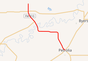
Farm to Market Road 810
Farm to Market Road 810 (FM 810) is a farm to market road in northern Clay County, Texas.[1]
| ||||
|---|---|---|---|---|

| ||||
| Route information | ||||
| Maintained by TxDOT | ||||
| Length | 8.985 mi[1] (14.460 km) | |||
| Existed | 1948–present | |||
| Major junctions | ||||
| South end | ||||
| North end | Charlie | |||
| Location | ||||
| Counties | Clay | |||
| Highway system | ||||
| ||||
Route description
FM 810 is a two-lane route for its entire length and connects Petrolia and Charlie. Its southern terminus is at SH 79 / SH 148 in central Petrolia. The route travels generally to the northwest, crossing the Wichita River before ending at Charlie, approximately one mile north of FM 171.[1][2]
History
FM 810 was previously part of SH 148. SH 148 previously continued from its current terminus in Petrolia northward to the Oklahoma state line, but was truncated to Charlie on August 1, 1941. The portion of SH 148 between Petrolia and Charlie was then transferred to FM 810 on August 24, 1948.[1][3]
Major intersections
The entire route is in Clay County.
| Location | mi[4] | km | Destinations | Notes | |
|---|---|---|---|---|---|
| Petrolia | 0.0 | 0.0 | Southern terminus | ||
| | 6.4 | 10.3 | |||
| | 8.0 | 12.9 | |||
| Charlie | 9.0 | 14.5 | T-Bone Rd. / N. Bevering Rd. | Northern terminus | |
| 1.000 mi = 1.609 km; 1.000 km = 0.621 mi | |||||
gollark: 10nm was initially a joke and then got sort of okay years behind schedule, and 7nm is hahahahano.
gollark: Intel has been consistently behind on their process stuff.
gollark: The way the pricing of stocks works, is far as I know, is that people who pay more attention to the company than "hmm their CPUs seem to be good" have already evaluated how well they think they'll do and bought/sold accordingly, so it's already reflected in the pricing.
gollark: Especially now with the ridiculous proliferation of them.
gollark: Most random 2¢ cryptocurrencies will not actually become worth anything.
References
- Transportation Planning and Programming Division (n.d.). "Farm to Market Road No. 810". Highway Designation Files. Texas Department of Transportation. Retrieved 2011-01-07.
- Transportation Planning and Programming Division (2012). Texas County Mapbook (PDF) (Map) (2012 ed.). 1:120,000. Texas Department of Transportation. p. 387. OCLC 867856197. Retrieved 2011-01-07.
- Transportation Planning and Programming Division (n.d.). "State Highway No. 148". Highway Designation Files. Texas Department of Transportation. Retrieved 2011-01-07.
- Google (2011-01-07). "Overview map of Farm to Market Road 810 Distances Between Interchanges" (Map). Google Maps. Google. Retrieved 2011-01-07.
This article is issued from Wikipedia. The text is licensed under Creative Commons - Attribution - Sharealike. Additional terms may apply for the media files.
