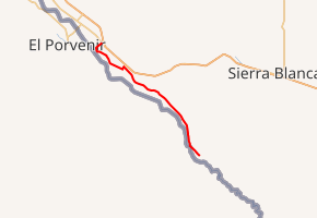
Farm to Market Road 192
Farm to Market Road 192 (FM 192) is a Farm to Market Road entirely in Hudspeth County in the U.S. state of Texas maintained by the Texas Department of Transportation (TxDOT). It generally parallels the Rio Grande for its entire length.
| ||||
|---|---|---|---|---|

| ||||
| Route information | ||||
| Maintained by TxDOT | ||||
| Length | 25.447 mi[1] (40.953 km) | |||
| Existed | 1945–present | |||
| Major junctions | ||||
| South end | Ranch Rd. along Rio Grande[2] | |||
| North end | ||||
| Location | ||||
| Counties | Hudspeth | |||
| Highway system | ||||
| ||||
Route description
The southern terminus of FM 192 is along the Rio Grande in unincorporated Hudspeth County. From here, the road proceeds northwestward along the river, passing through Fort Quitman and Esperanza before ending at SH 20 at McNary[1][2][3][4]
History
On June 11, 1945, FM 192 was assigned to a route from McNary on US 80 (present-day SH 20) via Esperanza to the Arroyo Balluco, approximately 12.0 miles (19.3 km). On July 21, 1949, the highway was extended 13.8 miles (22.2 km) further down the river to the Cox School, its present southern terminus.[1]
Major intersections
The entire route is in Hudspeth County.
| Location | mi | km | Destinations | Notes | |
|---|---|---|---|---|---|
| | 0.0 | 0.0 | Ranch Road – Indian Hot Springs | Southern terminus | |
| | |||||
| | |||||
| McNary | Former US 80 | ||||
| 1.000 mi = 1.609 km; 1.000 km = 0.621 mi | |||||
References
- Transportation Planning and Programming Division (n.d.). "Farm to Market Road No. 192". Highway Designation Files. Texas Department of Transportation. Retrieved 2011-09-22.
- Transportation Planning and Programming Division (2012). Texas County Mapbook (PDF) (Map) (2012 ed.). 1:120,000. Texas Department of Transportation. p. 81. OCLC 867856197. Retrieved 2011-09-22.
- Transportation Planning and Programming Division (2012). Texas County Mapbook (PDF) (Map) (2012 ed.). 1:120,000. Texas Department of Transportation. p. 76. OCLC 867856197. Retrieved 2011-09-22.
- Transportation Planning and Programming Division (2012). Texas County Mapbook (PDF) (Map) (2012 ed.). 1:120,000. Texas Department of Transportation. p. 77. OCLC 867856197. Retrieved 2011-09-22.
External links
![]()
