Farm to Market Road 1905
Farm To Market Road 1905 (FM 1905) is the first road that Interstate 10 interchanges with in Texas from New Mexico.[2] FM 1905 is a local road in the town of Anthony, which is located on the border with New Mexico. FM 1905 begins at the New Mexican border with NM 225, and ends at Interstate 10 in Anthony. There is a short segment concurrent with SH 20 along the way. FM 1905 was first assigned in 1951 and was extended to its current route in 1969.
| ||||
|---|---|---|---|---|
| ||||
| Route information | ||||
| Maintained by TxDOT | ||||
| Length | 2.169 mi[1] (3.491 km) | |||
| Existed | November 20, 1951–present | |||
| Major junctions | ||||
| West end | ||||
| East end | ||||
| Location | ||||
| Counties | El Paso | |||
| Highway system | ||||
| ||||

History
FM 1905 was assigned on November 20, 1951 from the state line to U.S. Highway 80 (now State Highway 20).[1] As the route was extended, stretching for 1.9 miles (3.1 km) to its current route in October 31, 1958.[1]
Route description
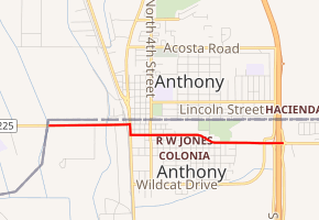
Farm To Market Road 1905 begins at the New Mexico border and NM 225 in Anthony. The road, known as West Washington Street, parallels the New Mexico-Texas border as it heads eastward towards downtown Anthony. There are intersections with local roads before intersecting and joining SH 20 at 0.8 of a mile. FM 1905 continues eastward again about 0.1 of a mile further south along SH 20, now heading towards Interstate 10 on Franklin Street. FM 1905 passes to the south of Enrique Miramontes Memorial Park and leaves downtown Anthony.[3]
FM 1905 becomes known as Antonio Street as it enters the outskirts of Anthony, where it intersects with Spur 6 before coming to an end at Exit 0 of Interstate 10.[3] Attractions along Road 1905 include the Anthony Street/Park yard on Antonio Street.[4] Road 1905 also has much of the towns food and groceries, including a McDonald's, Big 8 Food Store, Subway and several non-chain restaurants including the Rose Garden.[5]
Major intersections
The entire route is in Anthony, El Paso County.
| mi[1][3] | km | Destinations | Notes | ||
|---|---|---|---|---|---|
| 0.00 | 0.00 | New Mexico state line | |||
| 0.7 | 1.1 | Western end of SH 20 concurrency | |||
| 0.8 | 1.3 | Eastern end of SH 20 concurrency | |||
| 2.0 | 3.2 | Northern terminus of Spur 6 | |||
| 2.17 | 3.49 | Exit 0 (I-10) | |||
1.000 mi = 1.609 km; 1.000 km = 0.621 mi
| |||||
References
- Transportation Planning and Programming Division (n.d.). "Farm to Market Road No. 1905". Highway Designation Files. Texas Department of Transportation.
- Google (2008-01-18). "overview map of I-10 for Exit 0" (Map). Google Maps. Google. Retrieved 2008-01-18.
- Google (2008-01-15). "overview map of Farm To Market Road 1905" (Map). Google Maps. Google. Retrieved 2008-01-15.
- http://townofanthony.org/parks_recreation.php Archived 2009-04-27 at the Wayback Machine Town of Anthony Parks web site. Retrieved on 2009.05.12
- Restaurants in Anthony, Texas accessed January 18, 2007
External links