Farm to Market Road 1901
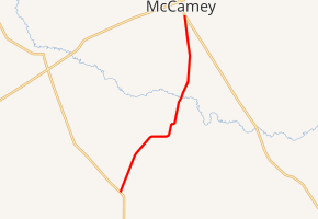
Farm to Market Road 1901 (FM 1901) is a Farm to Market Road in the U.S. state of Texas maintained by the Texas Department of Transportation (TxDOT). The road, located in Pecos, Crockett, and Upton counties, connects FM 11 near Bakersfield with FM 305 in McCamey and passes through the small community of Bakersfield Valley.
| ||||
|---|---|---|---|---|

| ||||
| Route information | ||||
| Maintained by TxDOT | ||||
| Length | 15.419 mi[1] (24.814 km) | |||
| Existed | 1951[1]–present | |||
| Major junctions | ||||
| South end | ||||
| North end | ||||
| Location | ||||
| Counties | Pecos, Crockett, Upton | |||
| Highway system | ||||
| ||||
Route description
The 15.4-mile (24.8 km) two-lane road begins at FM 11 approximately 2.6 miles (4.2 km) north of Bakersfield in eastern Pecos County and proceeds to the northeast.[2] The road passes through Bakersfield Valley before crossing the Pecos River into Crockett County. The road traverses the northwest corner of Crockett County for approximately 4 miles (6.4 km) where the road turns to the north. The road enters southwestern Upton County approximately 1.6 miles (2.6 km) south of its northern terminus with FM 305 along the southern edge of McCamey.[3]
History
FM 1901 was designated along its current length on December 18, 1951.[1]
Major intersections
| County | Location | mi[4] | km | Destinations | Notes | |||
|---|---|---|---|---|---|---|---|---|
| Pecos | | 0.0 | 0.0 | Southern terminus | ||||
| Crockett |
No major junctions | |||||||
| Upton | McCamey | 15.4 | 24.8 | Northern terminus | ||||
| 1.000 mi = 1.609 km; 1.000 km = 0.621 mi | ||||||||
See also
References
- Transportation Planning and Programming Division (n.d.). "Farm to Market Road No. 1901". Highway Designation Files. Texas Department of Transportation. Retrieved June 11, 2012.
- Transportation Planning and Programming Division (2014). Texas County Mapbook (PDF) (Map) (2014 ed.). 1:120,000. Texas Department of Transportation. p. 109. Retrieved December 6, 2014.
- Transportation Planning and Programming Division (2014). Texas County Mapbook (PDF) (Map) (2014 ed.). 1:120,000. Texas Department of Transportation. p. 108. Retrieved December 6, 2014.
- Google (June 11, 2012). "Route of FM 1901" (Map). Google Maps. Google. Retrieved June 11, 2012.
External links

