Farm to Market Road 1472
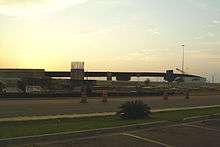
Farm to Market Road 1472 (FM 1472) is a farm-to-market road that connects the Laredo, Texas Industrial Area to the Colombia – Solidarity International Bridge, then running roughly parallel to the Rio Grande into rural Webb County. In the urban sections of Laredo, it is a six-lane route known locally as Mines Road.[1]
| ||||
|---|---|---|---|---|
| ||||
| Route information | ||||
| Length | 33.4 mi[1] (53.8 km) | |||
| Existed | 1955[1]–present | |||
| Major junctions | ||||
| South end | ||||
| North end | A point 14.7 miles (23.7 km) northwest of SH 255 | |||
| Location | ||||
| Counties | Webb | |||
| Highway system | ||||
| ||||

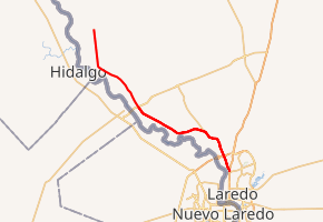
Route description
The southern terminus of FM 1472 is in Laredo, at IH 35 Exit #4. The route travels to the north and crosses I-69W/US 59/Loop 20.[2] It then takes more of a northwesterly direction, paralleling the Rio Grande. It has a junction with SH 255, the former Camino Colombia Toll Road, near the Laredo city limits.[3] The route continues through unincorporated Webb County before reaching the end of its designation north of Carricitos Creek. The unimproved roadway continues as Eagle Pass Road, which becomes the paved FM 1021 after crossing into Maverick County.[1][4]
History
FM 1472 was originally designated on July 20, 1948 on a route from US 82 in Crosbyton to Wake School in Crosby County; this route was cancelled and combined with FM 28 on November 1, 1954. The current FM 1472 was designated on April 1, 1955, from the junction of what was then US 81 to the community of Dolores, a distance of 17.8 miles.[1] The designation was extended four times: by 6.1 miles on May 2, 1962, by four miles on November 26, 1969, by another four miles on November 5, 1971, and by another two miles on October 21, 1981 to its current length. The portion of the route between Interstate 35 and SH 255 (formerly FM 255) was officially redesignated as Urban Road 1472 on June 27, 1995 due to the growth of the Laredo urban area and the construction of the Columbia-Solidarity International Bridge northwest of the city. As with other urban roads, the signage retains its Farm Road shields.[5]
Major intersections
The entire route is in Webb County.
| Location | mi[6] | km | Destinations | Notes | |
|---|---|---|---|---|---|
| Laredo | 0.0 | 0.0 | I-35 exit 4A; southern terminus. | ||
| 2.2 | 3.5 | ||||
| 18.8 | 30.3 | ||||
| | 33.4 | 53.8 | Eagle Pass Road | Northern terminus and continuation | |
| 1.000 mi = 1.609 km; 1.000 km = 0.621 mi | |||||
References
- Transportation Planning and Programming Division (n.d.). "Farm to Market Road No. 1472". Highway Designation Files. Texas Department of Transportation. Retrieved December 6, 2014.
- Transportation Planning and Programming Division (2014). Texas County Mapbook (PDF) (Map) (2014 ed.). 1:120,000. Texas Department of Transportation. p. 287. Retrieved December 6, 2014.
- Transportation Planning and Programming Division (2014). Texas County Mapbook (PDF) (Map) (2014 ed.). 1:120,000. Texas Department of Transportation. p. 261. Retrieved December 6, 2014.
- Transportation Planning and Programming Division (2014). Texas County Mapbook (PDF) (Map) (2014 ed.). 1:120,000. Texas Department of Transportation. p. 260. Retrieved December 6, 2014.
- Transportation Planning and Programming Division (n.d.). "Urban Road No. 1472". Highway Designation Files. Texas Department of Transportation. Retrieved December 6, 2014.
- Google (January 5, 2011). "Overview map of Farm to Market Road 1472 Distances Between Interchanges" (Map). Google Maps. Google. Retrieved January 5, 2011.