Farina, South Australia
Farina, formerly Farina Town, is a town and locality in the Australian state of South Australia. At the 2006 census, Farina had a population of 55.[8]
| Farina South Australia | |||||||||||||||
|---|---|---|---|---|---|---|---|---|---|---|---|---|---|---|---|
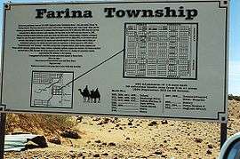 Farina Sign | |||||||||||||||
 Farina | |||||||||||||||
| Coordinates | 30°04′30″S 138°16′34″E[1] | ||||||||||||||
| Population | 29 (shared with other localities in the "State Suburb of Farina") (2016 census)[2] [lower-alpha 1] | ||||||||||||||
| Established | 21 March 1878 (town) 29 May 1997 (locality)[3][4] | ||||||||||||||
| Postcode(s) | 5733 | ||||||||||||||
| Time zone | ACST (UTC+9:30) | ||||||||||||||
| • Summer (DST) | ACDT (UTC+10:30) | ||||||||||||||
| LGA(s) | Pastoral Unincorporated Area[1] | ||||||||||||||
| Region | Far North[1] | ||||||||||||||
| State electorate(s) | Stuart[5] | ||||||||||||||
| Federal Division(s) | Grey[6] | ||||||||||||||
| |||||||||||||||
| |||||||||||||||
| Footnotes | Adjoining localities[1] | ||||||||||||||
On the edge of the desert, it sits within the Lake Eyre Basin and it is situated on the old alignment of the Ghan railway, 26 kilometres (16 mi) north of Lyndhurst and 55 kilometres (34 mi) south of Marree where the Oodnadatta Track and the Birdsville Track commence.[9]
History
Originally called The Gums or Government Gums,[10] Farina was settled in 1878 by optimistic farmers hoping that rain follows the plough.[11] The town was the railhead for a time until 1884 before the railway was extended to Marree. During the wet years of the 1880s, plans were laid out for a town with 432 ¼-acre blocks. It was believed that it would be good for growing wheat and barley, however normal rainfall is nowhere near enough to grow these crops. Several silver and copper mines were dug in the surrounding area.
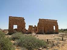
Farina grew to reach a peak population of approximately 600 in the late 1800s. In its heyday, the town had two hotels (the Transcontinental and the Exchange) and an underground bakery, a bank, two breweries, a general store, an Anglican church, five blacksmiths, a school and a brothel. In 1909, a 1,143 kilograms (2,520 lb) iron meteorite was discovered north-east of the town.
Today nothing but stone ruins and the elevated railway water tank remain of the township. The post office closed in the 1960s and the railway line closed in the 1980s.
The town is no longer inhabited, with the closest residents now living at Farina station, visible to the west of the town. A bush camping area is maintained by the owners of Farina station.
In 2008 Farina Restoration Group was formed, and in May 2009, 30 people attended a 14-day restoration program at Farina.[12]
Volunteer efforts have been made to restore the town, including the repair of the bakery and the addition of informational signs.[13]
Cemeteries
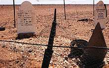
The town's cemetery is located a few kilometres away via a signposted track. Of interest is the Afghan corner of the cemetery which contains several headstones with both English and Arabic inscriptions, plus several headstones without inscriptions, marking the resting place of former Farina residents of Afghan origin who were involved in or connected to the Afghan camel trains which used to provide transport services before the railway was extended. All the gravestones face Mecca in the Islamic tradition.
World War I
During World War I, 33 men who were born in Farina enlisted for the duration of the war and for four months after its end. All of them were volunteers. The first man enlisted at Helena Vale in South Australia on 28 August 1914 and joined the 11th Battalion. The last man enlisted on the 23 March 1918.
Of the 33 men who went to war from Farina, 5 were killed in action, 10 were wounded and one died at sea, en route to England. One of the youngest men to enlist was William James Denham Robinson... he was 15 and had an alias of Charles Robison. He was born in Mt. Lyndhurst and lived in Farina and was in WW1 and WW2.
The last survivors were discharged on 16 August 1920.
World War II
During World War II, 35 men born in Farina enlisted. Of those, nine served in the Royal Australian Air Force. The first man enlisted on 18 October 1939 and the last man in 15 March 1945. The youngest was 18 when he enlisted and the oldest was 45. Three men were killed in action and a fourth died during his service in the army. The last Farina man was discharged in October 1948.
Climate
Farina has a hot desert climate, although the temperature station has not been in operation since 1939.[7]
| Climate data for Farina 1889–1939 normals, rainfall 1879-2018 | |||||||||||||
|---|---|---|---|---|---|---|---|---|---|---|---|---|---|
| Month | Jan | Feb | Mar | Apr | May | Jun | Jul | Aug | Sep | Oct | Nov | Dec | Year |
| Record high °C (°F) | 46.7 (116.1) |
45.6 (114.1) |
43.3 (109.9) |
38.9 (102.0) |
33.1 (91.6) |
30.0 (86.0) |
30.0 (86.0) |
31.7 (89.1) |
37.8 (100.0) |
43.1 (109.6) |
44.2 (111.6) |
46.4 (115.5) |
46.7 (116.1) |
| Average high °C (°F) | 35.5 (95.9) |
35.4 (95.7) |
32.0 (89.6) |
26.5 (79.7) |
21.6 (70.9) |
17.7 (63.9) |
17.3 (63.1) |
19.8 (67.6) |
23.7 (74.7) |
27.9 (82.2) |
31.9 (89.4) |
34.5 (94.1) |
27.0 (80.6) |
| Average low °C (°F) | 19.9 (67.8) |
20.0 (68.0) |
17.0 (62.6) |
12.1 (53.8) |
8.1 (46.6) |
5.5 (41.9) |
4.1 (39.4) |
5.7 (42.3) |
8.5 (47.3) |
12.5 (54.5) |
16.1 (61.0) |
18.7 (65.7) |
12.4 (54.3) |
| Record low °C (°F) | 10.6 (51.1) |
10.6 (51.1) |
7.8 (46.0) |
2.7 (36.9) |
−1.4 (29.5) |
−2.8 (27.0) |
−3.8 (25.2) |
−2.2 (28.0) |
0.6 (33.1) |
2.8 (37.0) |
5.6 (42.1) |
7.8 (46.0) |
−3.8 (25.2) |
| Average precipitation mm (inches) | 18.8 (0.74) |
19.7 (0.78) |
15.2 (0.60) |
10.7 (0.42) |
14.7 (0.58) |
16.0 (0.63) |
9.3 (0.37) |
10.7 (0.42) |
10.6 (0.42) |
12.9 (0.51) |
12.3 (0.48) |
15.1 (0.59) |
165.0 (6.50) |
| Source: [7] | |||||||||||||
See also
- Farina (disambiguation)
References
- Notes
- For the 2016 census, the 'State Suburb of Farina' consisted of Farina and other localities within an area extending from the shore of Lake Torrens in the south to immediately north of Marree but not including Marree.[2]
- Citations
- "Search results for 'Farina, LOCB' with the following datasets being selected - 'Suburbs and Localities', 'Government Towns', 'Local Government Areas', 'SA Government Regions' and 'Gazetteer'". Location SA Map Viewer. Government of South Australia. Retrieved 22 March 2019.
- Australian Bureau of Statistics (27 June 2017). "Farina". 2016 Census QuickStats. Retrieved 22 March 2019.

- Morgan, William (21 March 1878). "Untitled proclamation re the "Township of Farina Town"" (PDF). The South Australian Government Gazette. Government of South Australia. p. 621. Retrieved 22 March 2019.
- Kentish, P.M. (29 May 1997). "GEOGRAPHICAL NAMES ACT 1991 Notice to Assign Boundaries to Places (localities of Beltana, Cockburn, Marree, Farina and Waukaringa)" (PDF). The South Australian Government Gazette. South Australian government. p. 2691. Retrieved 20 February 2018.
- "District of Stuart Background Profile". ELECTORAL COMMISSION SA. Retrieved 22 March 2019.
- "Federal electoral division of Grey, boundary gazetted 16 December 2011" (PDF). Australian Electoral Commission. Retrieved 22 March 2019.
- "Monthly climate statistics: Summary statistics MARREE (FARINA) (nearest station)". Commonwealth of Australia , Bureau of Meteorology. Retrieved 23 March 2019.
- Australian Bureau of Statistics (25 October 2007). "Farina (State Suburb)". 2006 Census QuickStats. Retrieved 30 July 2011.
- "The rescue of Farina". farinarestoration.com. Retrieved 5 June 2016.
- Basil Fuller: The Ghan – The Story of the Alice Springs Railway. Sydney 1975. ND 2003.ISBN 978-1-74110-806-4
- http://www.australiangeographic.com.au/travel/destinations/2010/05/six-of-the-best-ghost-towns/ Brennan, Bridget (2010). "Six of the best ghost towns", Australian Geographic, Issue 97, 21 May.
- "The Farina time-line". farinarestoration.com. Retrieved 5 June 2016.
- Mike Sexton (20 June 2013). "Grey nomad volunteers are dusting off an outback ghost town". ABC News.
External links
| Wikimedia Commons has media related to Farina, South Australia. |