Faraway How
Faraway How is a nunatak in King Christian X Land, East Greenland. Administratively it falls under the Northeast Greenland National Park zone.
| Faraway How | |
|---|---|
 Faraway How | |
| Highest point | |
| Elevation | 1,398 m (4,587 ft) [1] |
| Coordinates | 74°25′N 23°33′W [2] |
| Geography | |
| Location | King Christian X Land, Greenland |
| Climbing | |
| First ascent | Unknown |
This geographic feature was named by the 1926 Cambridge Expedition to East Greenland led by Sir James Wordie.[3]
Geography
Faraway How is located in the Wordie Glacier north of Steno Land and 9 km to the west of C. H. Ostenfeld Nunatak's northern end.[2]
Faraway How is 7.8 km in length and its maximum width is 3.2 km; the highest elevation is located at the western end and is 1,398 metres (4,587 ft) high.[1]
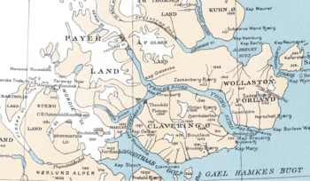 1932 map section showing Faraway How and the Wordie Glacier on the left. |
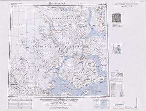 Detailed map of the area. |
gollark: I'm aware of some of the many hard to find but easy to verify ones.
gollark: No, what I mean is, are there easy to find but hard to verify problems?
gollark: No, other way round.
gollark: There are probably problems like that maybe. I think mostly for cryptography.
gollark: Well, you could set up your tax form such that it's easy for you to make and hard for them to verify.
See also
- List of mountains in Greenland
- List of nunataks of Greenland
Bibliography
- Wordie, J. M.; Manley, G.; White, P. F.; Johnson, D. McI. (1927). "The Cambridge Expedition to East Greenland in 1926". The Geographical Journal. 70 (3): 225–265. doi:10.2307/1781943. JSTOR 1781943.
References
- GoogleEarth
- "Faraway How". Mapcarta. Retrieved 8 July 2016.
- "Catalogue of place names in northern East Greenland". Geological Survey of Denmark. Retrieved 8 July 2016.
This article is issued from Wikipedia. The text is licensed under Creative Commons - Attribution - Sharealike. Additional terms may apply for the media files.