C. H. Ostenfeld Nunatak
C. H. Ostenfeld Nunatak is a nunatak in King Christian X Land, East Greenland. Administratively it falls under the Northeast Greenland National Park zone.
| C. H. Ostenfeld Nunatak | |
|---|---|
 C. H. Ostenfeld Nunatak | |
| Highest point | |
| Elevation | 1,019 m (3,343 ft) [1] |
| Coordinates | 74°17′N 22°56′W [2] |
| Geography | |
| Location | King Christian X Land, Greenland |
| Climbing | |
| First ascent | Unknown |
This geographic feature was named by Lauge Koch during his 1929–30 expeditions after Danish botanist Carl Hansen Ostenfeld (1873–1931), author of Flora of Greenland and its origin.[3]
Geography
It is a relatively large nunatak located east of Stenoland between the Wordie Glacier and the Granta Glacier. Its northern end lies 9 km to the east of Faraway How's eastern point.[2]
C. H. Ostenfeld Nunatak is 15.7 km in length and its maximum width is 6.4 km; the highest elevation is located at the western end and is 1,019 metres (3,343 ft) high.[1]
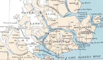 1932 map section showing C. H. Ostenfeld Nunatak and the Wordie Glacier on the left. |
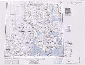 Detailed map of the area. |
gollark: There is, yes.
gollark: It reminds me of this great pairing.
gollark: I refuse to substantially complicate everything for one moderately nice thing.
gollark: I could make a central deadlinks list without horrible issues, though.
gollark: So it knows exactly where all the links go.
See also
- List of nunataks of Greenland
References
- GoogleEarth
- "C. H. Ostenfeld Nunatak". Mapcarta. Retrieved 9 July 2016.
- "Catalogue of place names in northern East Greenland". Geological Survey of Denmark. Retrieved 8 July 2016.
This article is issued from Wikipedia. The text is licensed under Creative Commons - Attribution - Sharealike. Additional terms may apply for the media files.