Fairfield Township, Lenawee County, Michigan
Fairfield Township is a civil township of Lenawee County in the U.S. state of Michigan. As of the 2000 census, the township population was 1,756.
Fairfield Township, Michigan | |
|---|---|
.jpg) Fairfield Township Hall in Jasper | |
%2C_MI_location.png) Location within Lenawee County (red) and the administered community of Jasper (pink) | |
 Fairfield Township Location within the state of Michigan | |
| Coordinates: 41°46′41″N 84°04′08″W | |
| Country | United States |
| State | Michigan |
| County | Lenawee |
| Government | |
| • Supervisor | Larry Keck |
| • Clerk | Debra Keller |
| Area | |
| • Total | 42.0 sq mi (108.7 km2) |
| • Land | 42.0 sq mi (108.7 km2) |
| • Water | 0.0 sq mi (0.0 km2) |
| Elevation | 755 ft (230 m) |
| Population (2000) | |
| • Total | 1,756 |
| • Density | 41.8/sq mi (16.2/km2) |
| Time zone | UTC-5 (Eastern (EST)) |
| • Summer (DST) | UTC-4 (EDT) |
| ZIP code(s) | |
| Area code(s) | 517 |
| FIPS code | 26-27020[1] |
| GNIS feature ID | 1626263[2] |
| Website | www |
Communities
- Fairfield is an unincorporated community at the junction of M-52 and Farifield Road at 41°48′46″N 84°02′28″W.[3] It was first known as Baker's Corners after the brothers Moses, Orin, and Joseph Baker bought land here in 1831-32. A post office named Baker's opened January 29, 1835, with Orrin Baker as the first postmaster. It was renamed to Fairfield after the township on April 13, 1842. The post office was discontinued July 15, 1921.[4][5]
- Jasper is an unincorporated community on M-52 approximately one mile south of Fairfield at 41°47′36″N 84°02′26″W.[6] The first European settler was Andrew Millet, arriving in 1824. A post office was opened June 18, 1874, with Henry Ferguson as the first postmaster.[4][7] The ZIP code for the Jasper post office is 49248.[8] The Lake Shore and Michigan Southern Railway had a depot in Jasper.[9] The station was at first known as Fairfield.[4]
- Ridgeville is a historical locale at the junction of Arnold Highway and E. Ridgeville Road at 41°45′26″N 84°01′18″W.[10] A post office opened December 9, 1898, and operated until November 29, 1902.[4][11]
- Weston is an unincorporated community at the junction of Sand Creek Highway and W. Weston Road at 41°46′13″N 84°05′52″W.[12] Ezra Cole was the first European settler of Weston in 1835. Initially known as Oakford, a post office opened with that name on July 27, 1854, with Northright Knapp as the first postmaster. On June 15, 1869, the post office was renamed Weston after professional pedestrian Edward Payson Weston.[4][13] The ZIP code for the Weston post office is 49289.[8] The Lake Shore and Michigan Southern Railway had a depot in Weston.[14]
Geography
According to the United States Census Bureau, the township has a total area of 42.0 square miles (108.7 km2), all land.
Demographics
As of the census[1] of 2000, there were 1,756 people, 621 households, and 481 families residing in the township. The population density was 41.8 per square mile (16.2/km2). There were 666 housing units at an average density of 15.9 per square mile (6.1/km2). The racial makeup of the township was 97.49% White, 0.11% African American, 0.57% Native American, 0.06% Asian, 0.63% from other races, and 1.14% from two or more races. Hispanic or Latino of any race were 3.87% of the population.
There were 621 households, out of which 38.0% had children under the age of 18 living with them, 67.8% were married couples living together, 6.4% had a female householder with no husband present, and 22.4% were non-families. 19.5% of all households were made up of individuals, and 9.2% had someone living alone who was 65 years of age or older. The average household size was 2.81 and the average family size was 3.22.
In the township the population was spread out, with 29.4% under the age of 18, 7.7% from 18 to 24, 27.6% from 25 to 44, 24.3% from 45 to 64, and 11.0% who were 65 years of age or older. The median age was 37 years. For every 100 females, there were 99.8 males. For every 100 females age 18 and over, there were 95.1 males.
The median income for a household in the township was $42,900, and the median income for a family was $47,330. Males had a median income of $35,690 versus $24,259 for females. The per capita income for the township was $17,496. About 2.7% of families and 4.8% of the population were below the poverty line, including 6.0% of those under age 18 and 4.2% of those age 65 or over.
References
- "U.S. Census website". United States Census Bureau. Retrieved 2008-01-31.
- U.S. Geological Survey Geographic Names Information System: Fairfield Township, Lenawee County, Michigan
- U.S. Geological Survey Geographic Names Information System: Fairfield, Michigan
- Romig, Walter (1986) [1973]. Michigan Place Names. Detroit, Michigan: Wayne State University Press. ISBN 0-8143-1838-X.
- U.S. Geological Survey Geographic Names Information System: Fairfield Post Office (historical)
- U.S. Geological Survey Geographic Names Information System: Jasper, Michigan
- U.S. Geological Survey Geographic Names Information System: Jasper Post Office
- ZIP Code Lookup Archived 2010-11-23 at WebCite, United States Postal Service
- Jasper, Michigan Archived 2011-05-25 at the Wayback Machine, Michigan's Internet Railroad History Museum]
- U.S. Geological Survey Geographic Names Information System: Ridgeville, Michigan
- U.S. Geological Survey Geographic Names Information System: Ridgeville Post Office (historical)
- U.S. Geological Survey Geographic Names Information System: Weston, Michigan
- U.S. Geological Survey Geographic Names Information System: Weston Post Office
- Weston, Michigan Archived 2011-06-22 at the Wayback Machine, Michigan's Internet Railroad History Museum]
External links
Municipalities and communities of Lenawee County, Michigan, United States | ||
|---|---|---|
| Cities | 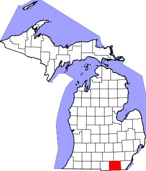 Map of Michigan highlighting Lenawee County.svg | |
| Villages | ||
| Charter townships | ||
| Civil townships | ||
| CDPs | ||
| Other unincorporated communities | ||
| Footnotes | ‡This populated place also has portions in an adjacent county or counties | |