Extreme points of the Czech Republic
This is a list of the extreme points of the Czech Republic: the points that are farther north, south, east or west than any other location.

Sněžka
Studánky
Severní
Krásná
Bukovec
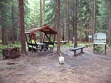
Hřensko
Extreme points of the Czech Republic
Latitude and longitude
- North : Severní, part of Lobendava municipality, Ústí nad Labem Region (51°03′20″N 14°18′53″E)
- South : Studánky, part of Vyšší Brod municipality, South Bohemian Region (48°33′09″N 14°19′59″E)
- West : Krásná near Aš, Karlovy Vary Region (50°15′07″N 12°05′29″E)
- East : Bukovec, Moravian-Silesian Region (49°33′01″N 18°51′32″E)
Altitude
- Maximum : Sněžka Mountain, Hradec Králové Region, 1,603 m
- Minimum : Elbe River in Hřensko, Ústí nad Labem Region, 115 m (50°53′15″N 14°13′59″E)
- Depth: Hranice Abyss, by Hranice (Přerov District), over 473 m (404 meters under the water level)
 Northernmost point
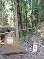 Easternmost point
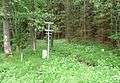 Southernmost point
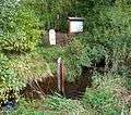 Westernmost point
.jpg) Mt. Sněžka
Mt. Sněžka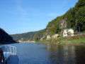 Elbe River in Hřensko
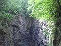 Hranice Abyss
gollark: It's actually just interfaced to the backend for potatOS.
gollark: I'm not running any now, see.
gollark: Yes, it waits for my commands.
gollark: Also, I have the Haskell LLVM bindings working so none are safe.
gollark: Yes it does. I checked.
This article is issued from Wikipedia. The text is licensed under Creative Commons - Attribution - Sharealike. Additional terms may apply for the media files.