Extreme points of Kyrgyzstan
This is a list of the extreme points of Kyrgyzstan.
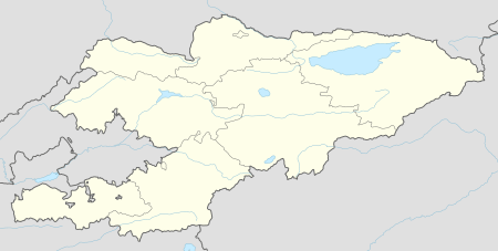
North
South
West
East
Highest
Extreme points of Kyrgyzstan
Cardinal directions
The northernmost region of Kyrgyzstan is Chuy Region.[1]
Elevation
At 7,439 m (24,406 ft) above sea level, Jengish Chokusu is the highest point of Kyrgyzstan.[2]
At 132 m (433 ft) above sea level, the lowest point of Kyrgyzstan is in the Kara Darya (Kara-Daryya, Karadar'ya),[2] which is a tributary of the Syr Darya, a river that flows into the North Aral Sea.
gollark: Yep.
gollark: AMD's new EPYC CPUs have a Cortex-A5 core in them for something or other, you know. ARM is *everywhere*.
gollark: I don't actually *need* more than a few slow ARM cores.
gollark: I'm happy with my phone's Snapdragon 430, apart from the security problems.
gollark: It's because they do a lot of optimization, can charge lots, and can easily update the OS and hardware in somewhat lockstep.
Notes
References
- Green Finance and Investment Promoting Clean Urban Public Transportation and Green Investment in Kyrgyzstan. OECD. 2019. p. 33. ISBN 978-92-64-34551-5 – via Google Books.
Bishkek is a separate administrative unit (independent city - shaar) and serves also as an administrative centre (apart from 2003-2006) of the surrounding Chui oblast (region), which is Kyrgyzstan's northernmost region.
- "KYRGYZSTAN". The World Factbook. Retrieved 1 February 2020.
lowest point: Kara-Daryya (Karadar'ya) 132 m highest point: Jengish Chokusu (Pik Pobedy) 7,439 m
| History |  | ||||
|---|---|---|---|---|---|
| Geography |
| ||||
| Politics | |||||
| Economy | |||||
| Society |
| ||||
| Sovereign states |
|
|---|---|
| States with limited recognition |
|
| Dependencies and other territories |
|
| |
This article is issued from Wikipedia. The text is licensed under Creative Commons - Attribution - Sharealike. Additional terms may apply for the media files.