European route E30 in the Netherlands
European route E 30 (E 30) is a west–east European route, running from Cork in Ireland to Omsk in Russia.[2][3] In the Netherlands, the highway runs from Hook of Holland eastwards through The Hague, Utrecht, Amersfoort and Apeldoorn to the German border, near De Lutte.
| ||||
|---|---|---|---|---|
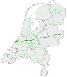 European routes in the Netherlands with E 30 in dark green | ||||
| Route information | ||||
| Maintained by Rijkswaterstaat[1] | ||||
| Major junctions | ||||
| West end | ||||
| East end | ||||
| Location | ||||
| Provinces | South Holland, Utrecht, Gelderland, Overijssel | |||
| Highway system | ||||
| ||||
The highway is maintained by Rijkswaterstaat.[1]
Route description
History
Exit list
| Province | Municipality | km | mi | Exit | Destinations | Notes | |
|---|---|---|---|---|---|---|---|
| South Holland | Rotterdam | 0.000 | 0.000 | Western end of N211 concurrency | |||
| Westland (municipality), Netherlands | |||||||
| The Hague | |||||||
| Westland (municipality), Netherlands | |||||||
| Midden-Delfland | 12 | Eastern end of N211 concurrency; western end of A4 concurrency | |||||
| Rijswijk | 11 | ||||||
| 10 | Diepenhorstlaan | ||||||
| The Hague | 9 | ||||||
| Eastern end of A4 concurrency; western end of A12 concurrency | |||||||
| 5 | Donau / Koning Willem-Alexanderviaduct | ||||||
| Zoetermeer | 6 | Zuidweg / Afrikaweg | Eastbound exit and westbound entrance | ||||
| 7 | |||||||
| Lansingerland | 8 | ||||||
| Zuidplas | 9 | ||||||
| Waddinxveen | Western end of E 25 concurrency | ||||||
| 11 | |||||||
| Bodegraven-Reeuwijk | 12 | ||||||
| 12a | |||||||
| 13 | Molendijk / Verlengde Tuurluur | ||||||
| Utrecht | Woerden | 14 | |||||
| 14a | |||||||
| Utrecht | 15 | ||||||
| Eastern end of E 25 concurrency; western end of E 35 concurrency | |||||||
| 16 | Papendorpseweg | ||||||
| Amsterdam–Rhine Canal | Galecopperbrug | ||||||
| Utrecht | Utrecht | 17 | Europalaan | ||||
| 18 | |||||||
| Eastern end of E 35 / A12 concurrency; Southern end of A27 concurrency | |||||||
| Northern end of A27 concurrency; western end of A28 concurrency | |||||||
| 2 | |||||||
| Zeist | 3 | ||||||
| Soest | 4 | ||||||
| Leusden | 5 | ||||||
| Amersfoort | 6 | ||||||
| Amersfoort–Leusden municipality line | 7 | Randweg | |||||
| Amersfoort | 8 | Hogeweg / Energieweg | |||||
| Eastern end of A28 concurrency; western end of A1 concurrency; | |||||||
| 14 | Amersfoortsestraat / Westerdorpsstraat / Nijkerkerstraat | ||||||
| Gelderland | Barneveld (municipality) | 15 | |||||
| 16 | |||||||
| 17 | |||||||
| Apeldoorn | 18 | ||||||
| 19 | |||||||
| 20 | Kayersdijk | ||||||
| 21 | |||||||
| Voorst | 22 | ||||||
| Overijssel | Deventer | 23 | south | ||||
| 24 | north | ||||||
| 25 | Marsdijk / Baarhorsterdijk | ||||||
| Rijssen-Holten | 26 | ||||||
| 27 | |||||||
| Wierden | 28 | ||||||
| Borne | Western end of A35 concurrency | ||||||
| 29 | Kluft | ||||||
| Eastern end of A35 concurrency | |||||||
| Hengelo | 30 | Rondweg / Bornestraat | |||||
| 31 | Oldenzaalsestraat / Hasselerbaan | ||||||
| Oldenzaal | 32 | Provinciale rondweg | |||||
| 33 | |||||||
| Losser | 34 | ||||||
| Continuation into Germany; eastern end of A1 concurrency; western end of A 30 concurrency | |||||||
1.000 mi = 1.609 km; 1.000 km = 0.621 mi
| |||||||
gollark: No.
gollark: Of course, if you do this, *you* know about human rights…
gollark: Human rights exist only in the minds of humans. Eliminate everyone who knows about them and they're gone.
gollark: You might be able to just approximate the humans, like in statistical mechanics.
gollark: Another angle might be high fidelity simulations of societies, but that has ethical issues too, and practical ones (simulating humans well enough is probably hard?).
See also


References
- "Wegbeheerders". Rijkswaterstaat. Retrieved 9 December 2014.
- "European Agrement on Main International Traffic Arteris (AGR)" (PDF). United Nations Economic and Social Council. 14 March 2008. p. 18. Retrieved 9 December 2014.
- "No. 21618 - Multilateral - European Agreement on main international traffic arteris (AGR) (with annexes and list of roads). Concluded at Geneva on 15 November 1975" (PDF). United Nations. 15 November 1975. Retrieved 9 December 2014.
External links

| Previous country: United Kingdom |
Netherlands | Next country: Germany |
This article is issued from Wikipedia. The text is licensed under Creative Commons - Attribution - Sharealike. Additional terms may apply for the media files.