Erdenet
Erdenet (Mongolian: Эрдэнэт, literally "with treasure") is the second-largest city in Mongolia, with a 2017 population of 97,814, and the capital of the aimag (province) of Orkhon. Located in the northern part of the country, it lies in a valley between the Selenge and Orkhon rivers about 240 km (149 mi) (as the bird flies) northwest of Ulaanbaatar, the capital. The road length between Ulaanbaatar and Erdenet is about 370 km (230 mi).
Erdenet Эрдэнэт ᠡᠷᠳᠡᠨᠢᠲᠦ | |
|---|---|
| Bayan-Öndör District Баян-Өндөр сум ᠪᠠᠶ᠋ᠠᠨᠥᠨᠳᠦᠷᠰᠤᠮᠤ | |
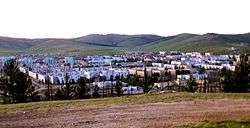
 View of Erdenet | |
 Seal | |
 Erdenet | |
| Coordinates: 49°01′40″N 104°02′40″E | |
| Country | Mongolia |
| Province | Orkhon Province |
| Founded | 1974 |
| Area | |
| • Total | 208.0 km2 (80.3 sq mi) |
| Elevation | 1,280 m (4,200 ft) |
| Population (2017) | |
| • Total | 97,814 |
| • Density | 470/km2 (1,200/sq mi) |
| Time zone | UTC+8 (UTC + 8) |
| Area code(s) | +976 7035 (7039) |
| Vehicle registration | OP_ ( _ variable) |
| Climate | Dwc |
| Website | www |
History
Erdenet, one of the youngest settlements in Mongolia, was founded in 1974[1] in an area where large deposits of copper had been discovered in the 1950s. A single-track railway line with a length of 120 km (75 mi) linking Erdenet to the Trans-Mongolian Railway was inaugurated in 1977.[2] In the middle of the 1980s, more than 50% of the inhabitants were Russians working as engineers or miners. After the fall of Soviet Communism in 1990, however, most Russians left Erdenet. Today, about 10% of the population is Russian.[1]
Erdenet Mining Corporation
The city hosts the fourth largest copper mine in the world. The Erdenet Mining Corporation is a joint Mongolian-Russian venture, and accounts for a majority of Mongolia's hard currency income. Erdenet mines 22.23 million tons of ore per year, producing 126,700 tons of copper and 1,954 tons of molybdenum.[3] The mine accounts for 13.5% of Mongolia's GDP and 7% of tax revenue.[4] About 8,000 people are employed in the mine.[5]
Infrastructure
Erdenet is linked to Ulaanbaatar, the capital of Mongolia, and to the towns of Darkhan and Bulgan by a paved road and is easily accessible by bus several times each day. The distance to the capital where the nearest airport is situated amounts to 370 km (230 mi) and travel by car takes about eight hours. Train connections between Erdenet and Ulaanbaatar are less comfortable as there is only one train per day covering the distance in 11 hours.
Sights
- Tourists are allowed to visit the mine by appointment. It is in the eastern part of the city, about 6 km (4 mi) from the centre.
- Another important economic factor of Erdenet is the carpet factory about 2 km (1 mi) from the center to the east which was founded in 1981. Every year, about 2,000 tons of wool are processed in the factory where about 1,100 people are employed.[6]
- The Mining Museum, in the Culture Palace on the central town square.[7]
- The Aimag Museum was founded in 1983.
- The Fraternity Monument dating from 1984 is on a hill offering a scenic view of the whole city in the northeastern part of Erdenet.
- A new temple with a large Buddha statue was built very recently in the eastern part of Erdenet.
- An amusement park was laid out in the east of the center.
- Amarbayasgalant Monastery is a Buddhist monastery about 60 km (37 mi) northeast of Erdenet. It was founded between 1727 and 1737, partially destroyed by order of Khorloogiin Choibalsan in 1937 and reconstructed after 1975 using financial aid provided by the UNESCO.
Population
| 1975 est. |
1979 census |
1981 est. |
1985 est. |
1989 census |
1994 est. |
2000 census |
2003 est. |
2004 est. |
2005 est. |
2006 est. |
2007 est. |
2008 est. |
|---|---|---|---|---|---|---|---|---|---|---|---|---|
| 4,100 | 31,900 | 38,700 | 45,400 | 56,100 | 63,000 | 68,310 | 78,882 | 80,858 | 81,249 | 83,160 | 85,121 | 86,866 |
Climate
Erdenet has a subarctic climate (Köppen climate classification: Dwc).
| Climate data for Erdenet | |||||||||||||
|---|---|---|---|---|---|---|---|---|---|---|---|---|---|
| Month | Jan | Feb | Mar | Apr | May | Jun | Jul | Aug | Sep | Oct | Nov | Dec | Year |
| Average high °C (°F) | −11.1 (12.0) |
−7.5 (18.5) |
0.2 (32.4) |
9.2 (48.6) |
16.9 (62.4) |
21.9 (71.4) |
22.0 (71.6) |
20.5 (68.9) |
15.8 (60.4) |
7.2 (45.0) |
−1.9 (28.6) |
−9.0 (15.8) |
7.0 (44.6) |
| Daily mean °C (°F) | −17.9 (−0.2) |
−15.2 (4.6) |
−7.9 (17.8) |
1.4 (34.5) |
8.4 (47.1) |
14.1 (57.4) |
15.5 (59.9) |
13.8 (56.8) |
8.2 (46.8) |
−0.3 (31.5) |
−9.0 (15.8) |
−15.5 (4.1) |
−0.4 (31.3) |
| Average low °C (°F) | −24.6 (−12.3) |
−22.8 (−9.0) |
−15.9 (3.4) |
−6.3 (20.7) |
−0.1 (31.8) |
6.4 (43.5) |
9.1 (48.4) |
7.2 (45.0) |
0.7 (33.3) |
−7.8 (18.0) |
−16.0 (3.2) |
−21.9 (−7.4) |
−7.7 (18.1) |
| Average precipitation mm (inches) | 3 (0.1) |
3 (0.1) |
7 (0.3) |
13 (0.5) |
22 (0.9) |
67 (2.6) |
96 (3.8) |
74 (2.9) |
42 (1.7) |
12 (0.5) |
8 (0.3) |
4 (0.2) |
351 (13.9) |
| Source: [14] | |||||||||||||
Gallery
 The "Fraternity Monument" in Erdenet
- City Centre
- Main Street
 City Centre
 Market in the center
 New Buddha Statue
 Residential area with LDS Church
 Typical residential area in the west of Erdenet
 Amusement park
Twin towns – sister cities
Erdenet is twinned with:
| City | Region | Country |
|---|---|---|
| Fairbanks | ||
| Ulan-Ude | ||
| Edremit[15] | ||
| Székesfehérvár[16] |
References
- Michael Kohn: Mongolia, p. 142, London (2008)
- Werner Elstner: Mongolei, p. 146, Berlin 1993
- Montsame News Agency. Mongolia (2006), Foreign Service Office of Montsame News Agency, ISBN 99929-0-627-8, pg. 80
- Montsame News Agency. Mongolia (2006), Foreign Service Office of Montsame News Agency; ISBN 99929-0-627-8, pg. 83
- Michael Kohn: Mongolia, p. 143, London (2008)
- Marion Wisotzki. Mongolei, p.227, Berlin 2010
- Michael Kohn: Mongolia, p. 144, London (2008)
- National Statistical Office Archived 7 June 2007 at the Wayback Machine
- National Economy of the Mongolian People's Republic (1921-1981), Ulaanbaatar (1981)
- "www.geohive.com geregistreerd via Argeweb - webhosting en domeinregistratie". www.geohive.com.
- "Population statistics: historical demography". www.populstat.info.
- Mongolia City Development Strategies for Secondary Cities, worldbank.org; accessed 22 February 2017.
- Statistical Report 2008 Archived 2011-07-22 at the Wayback Machine, statis.mn; accessed 22 February 2017.
- "Climate: Erdenet". Climate-Data.org. Retrieved March 3, 2018.
- "Sister/Twin Cities of Balıkesir Province" (PDF).
- Bozsoki, Agnes. "Partnervárosok Névsora Partner és Testvérvárosok Névsora" [Partner and Twin Cities List]. City of Székesfehérvár (in Hungarian). Archived from the original on 8 December 2012. Retrieved 22 February 2017.
External links
| Wikimedia Commons has media related to Erdenet. |
| Wikivoyage has a travel guide for Erdenet. |