Empire State Trail
The Empire State Trail is a 750-mile (1,210 km) multi-use trail that was proposed by Governor Andrew Cuomo in January 2017. The trail would run from Manhattan north to the northern tip of Lake Champlain and also from Buffalo to Albany. The trail will join existing trail segments, which will retain their existing identity but will be co-signed as a segment of the statewide Empire State Trail. The trail will also link to other regional bicycling and hiking trails such as the Appalachian Trail, the Adirondack and Catskill Parks, the Great Lakes Seaway Trail, the Genesee Valley Greenway, and others. A segment near its southernmost part, on the Hudson River Greenway in Manhattan, is concurrent with the East Coast Greenway. The trail will be used for hiking, biking, snowshoeing, cross-country skiing and in some areas snowmobiling.
| Empire State Trail | |
|---|---|
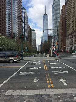
 The bikeway lanes of the Hudson River Greenway head north from Battery Park in New York City, marking the southern end of the Empire State Trail. The walking lane is to the left of the bikeway. | |
| Length | 750 mi (1,210 km) |
| Location | Buffalo-Albany-Manhattan, Albany-Lake Champlain |
| Use | Hiking, Biking, Snowmobiling |
| Hiking details | |
| Season | All year |
| Website | https://empiretrail.ny.gov/ |
Completing the trail will require 40 construction projects, to create new trails, and to eliminate gaps in existing segments.[1] The trail is to be completed by 2020.[2][1]
Route
The 750-mile (1,210 km) trail is organized in three main segments: the Hudson River Valley Greenway Trail, the Erie Canalway Trail, and the Champlain Valley Trail.[3] There is a proposal to extend the trail from its southern terminus into Long Island. [4]
Trail maintenance
The trail will connect existing trail segments operated by a variety of state entities, local governments, and non-profit organizations such as the New York State Canalway Trail, Dutchess Rail Trail, Wallkill Valley Rail Trail and others. The trail maintenance activities will continue to be undertaken by the entity that operates each local segment of the larger Empire State Trail.[1]
Trails included
- New York State Canalway Trail - Erie and Champlain Canalway Trails
- Walkway over the Hudson
- Hudson River Greenway
- North County Trailway
- South County Trailway
- Mohawk-Hudson Bike-Hike Trail
- Dutchess Rail Trail
- Hudson Valley Rail Trail
- Putnam County Trailway
- Wallkill Valley Rail Trail
- Onondaga Creekwalk
- Albany-Hudson Electric Trail
- Maybrook Trailway
- Shoreline Trail
- Kingston Point Rail Trail
- Delaware Avenue-Black Bridge Trail
- Old Putnam Trail
- Terry Gordon Bike Path
See also
External links
References
- Empire State Trail Program (August 8, 2017). Empire State Trail Plan Draft. Empire State Trail Program. Retrieved September 24, 2017.
- Brower, Ryan (September 18, 2017). "Project details for New York's 750-mile multi-use trail come to light in draft plan". GrindTV. Retrieved September 24, 2017.
- "Routes on the Empire State Trail". New York State. Retrieved 4 August 2018.
- "Long Island Extension of the Empire State Trail". The Trust for Public Land. Retrieved 17 Mar 2019.