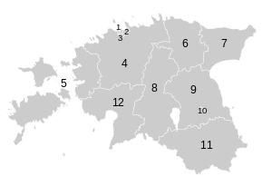
Electoral districts of Estonia
The Estonian Riigikogu, or Parliament, is made up of 101 members, elected from 12 separate geographic areas, or electoral districts. The constituency division is based on the counties of Estonia, of which some are combined or divided depending on the size of the population. The capital city Tallinn is divided into three electoral districts based on administrative districts within the city.[1] In the elections to the European Parliament, Estonia has only one national electoral district.[2]
Map of electoral districts
 |
Code | Electoral district |
|---|---|---|
| 1 | Haabersti, Põhja-Tallinn and Kristiine districts of Tallinn | |
| 2 | Kesklinn, Lasnamäe and Pirita districts of Tallinn | |
| 3 | Mustamäe and Nõmme districts of Tallinn | |
| 4 | Harju- (excl. Tallinn) and Raplamaa | |
| 5 | Hiiu-, Lääne- and Saaremaa | |
| 6 | Lääne-Virumaa | |
| 7 | Ida-Virumaa | |
| 8 | Järva- and Viljandimaa | |
| 9 | Jõgeva- and Tartumaa (excl. Tartu) | |
| 10 | Tartu | |
| 11 | Võru-, Valga- and Põlvamaa | |
| 12 | Pärnumaa | |
| Source | ||
gollark: I think either it should keep the `..` in, or error `outside of root directory`.
gollark: That's... honestly not great, in my opinion.
gollark: No.
gollark: Thanks. I probably should have checked which way round it goes.
gollark: <@237328509234708481> What's going on with this?
References
- "Riigikogu Election Act". Riigi Teataja. Retrieved 15 March 2015.
- "European Parliament Election Act". Riigi Teataja. Retrieved 15 March 2015.
This article is issued from Wikipedia. The text is licensed under Creative Commons - Attribution - Sharealike. Additional terms may apply for the media files.