Elati, Kozani
Elati (Greek: Ελάτη) is a village in the Kozani regional unit, Greece. It is part of the municipal unit Kamvounia.
Elati (Louziani) Ελάτη | |
|---|---|
 Seal | |
 Elati (Louziani) | |
| Coordinates: 39°58′N 21°49′E | |
| Country | Greece |
| Administrative region | West Macedonia |
| Regional unit | Kozani |
| Municipality | Servia |
| Municipal unit | Kamvounia |
| Area | |
| • Total | 40.0 km2 (15.4 sq mi) |
| Elevation | 650 m (2,130 ft) |
| Population (2011)[1] | |
| • Total | 415 |
| • Density | 10/km2 (27/sq mi) |
| Time zone | UTC+2 (EET) |
| • Summer (DST) | UTC+3 (EEST) |
| Postal code | 505 00 |
| Area code(s) | +30 24640 |
| Vehicle registration | ΚΖ |
| Website | www.kozanh.gr |
Gallery
 Elati seen from the west 2009
 Metamorphosis Church in Elati 2009
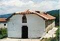 Saint Paraskevi's Church
 Saint Nikanoras Monastery west of Elati 2009
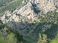 Hermitage close to Elati 2009
 View over Elati into the valley 2009
 Traditional dances
 Educational association
 Football club "Elatos"
 Rogatziarika at New Year
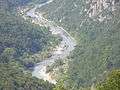 Panoramic view of Aliakmon river
 Steel bridge over Aliakmonas river west of Elati 2009
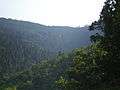 The fir-rich forest
 Forest landscape
gollark: firecubez simulator?
gollark: I mean, based on timing, you're asking me, but that doesn't make sense since I can communicate fine.
gollark: *Who* couldn't communicate at all?
gollark: ????????????????
gollark: ?????
References
- "Απογραφή Πληθυσμού - Κατοικιών 2011. ΜΟΝΙΜΟΣ Πληθυσμός" (in Greek). Hellenic Statistical Authority.
This article is issued from Wikipedia. The text is licensed under Creative Commons - Attribution - Sharealike. Additional terms may apply for the media files.