El Negrito
El Negrito (Spanish pronunciation: [el neˈɣɾito]) is a municipality in the department of Yoro, Honduras.
El Negrito | |
|---|---|
Municipality | |
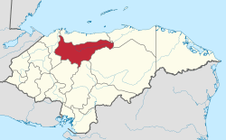
 El Negrito Location in Honduras | |
| Coordinates: 15°19′N 87°42′W | |
| Country | Honduras |
| Department | Yoro |
| Villages | 27 |
| Area | |
| • Total | 514.15 km2 (198.51 sq mi) |
| Population (2015) | |
| • Total | 46,523 |
| • Density | 90/km2 (230/sq mi) |
| Time zone | UTC-6 (Central America) |
| Climate | Aw |
Villages
El Negrito has a total of 29 villages:
- El Negrito
- Battán
- Aldea Paujiles Norte
- Campo Perdeíz
- Cerro Prieto No.1
- Cerro Prieto No.2
- El Jocomico
- El Junco
- El Naranjo
- El Pate
- El Robledal
- El Rodeo
- Estero Indio
- Finca Treinta and Cinco
- Finca Treinta and Seis
- Guaymón No.1
- La Laguna
- La Majada
- La Veinte and Nueve
- La Veinte and Ocho
- Las Delicias
- Nueva San Antonio
- Samar
- San Jerónimo
- San José del Negrito
- Toyos
- Villa del Carmen and Treinta and Siete
- Guangolola 1
- Guangolola 2
gollark: I'm sure you'd like to think so.
gollark: We have highly subtle memetics operating and some much less subtle propaganda posters prepared.
gollark: Of course you wouldn't. We saw to that, too.
gollark: We ensured that they won't, at least in sufficient quantities to matter.
gollark: Yes.
This article is issued from Wikipedia. The text is licensed under Creative Commons - Attribution - Sharealike. Additional terms may apply for the media files.