Ebersberg (district)
Ebersberg is a Landkreis (district) in Bavaria, Germany. It is bounded by (from the north and clockwise) the districts of Erding, Mühldorf, Rosenheim and Munich.
Ebersberg | |
|---|---|
%26groups%3D_78329669f602a7088dda44453306ffbb0966c8cc.svg)
| |
| Country | Germany |
| State | Bavaria |
| Adm. region | Upper Bavaria |
| Capital | Ebersberg |
| Area | |
| • Total | 549.3 km2 (212.1 sq mi) |
| Population (31 December 2018)[1] | |
| • Total | 142,142 |
| • Density | 260/km2 (670/sq mi) |
| Time zone | UTC+01:00 (CET) |
| • Summer (DST) | UTC+02:00 (CEST) |
| Vehicle registration | EBE |
| Website | http://www.lra-ebe.de |
History
The most important event in the district's history was the battle of Hohenlinden on December 3, 1800, which was a part of the Napoleonic Wars.
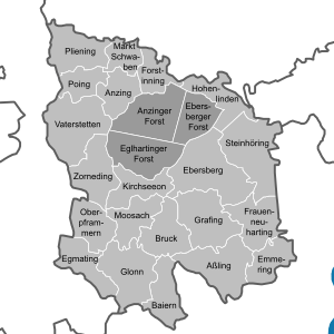
Geography
The district includes rural areas east of the city of Munich. Despite the vicinity of Munich urbanisation is low. In the north there is a contiguous forest area of 80 km², serving as recreation area for the population of the Bavarian capital. The forest consists of three separate unincorporated areas, Anzinger Forst, Ebersberger Forst, and Eglhartinger Forst.
Coat of arms
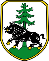
The arms display both parts of the word "Ebersberg": a boar (German "Eber") standing on a mountain (German "Berg"). These two symbols are part of the arms of the city of Ebersberg as well. In addition the district's arms include a fir, symbolising the forests of the region.
Towns and municipalities
| Towns | Municipalities | |
|---|---|---|
Unincorporated Areas
- Anzinger Forst
- Ebersberger Forst
- Eglhartinger Forst
References
- "Fortschreibung des Bevölkerungsstandes". Bayerisches Landesamt für Statistik und Datenverarbeitung (in German). July 2019.
External links
| Wikimedia Commons has media related to Landkreis Ebersberg. |
- Official website (German)
Towns and municipalities in Ebersberg (district) | ||
|---|---|---|
| Authority control |
|
|---|