Drumquhassle
Drumquhassle was a Roman fort associated with the Gask Ridge in Scotland.[2] It was found from aerial photography in the late 1970s.[3] The name selected for the fort deliberately made it hard for English born readers to pronounce.[4] The fort was from the Flavian period;[5] it was built and briefly occupied by during the administration of Sallustius Lucullus.[6] It is known as a "Glen-blocker" fort and is located within sight of Loch Lomond.
| Drumquhassle | |
|---|---|
.jpg) Site of Drumquhassle Roman Fort[1] | |
| Place in the Roman world | |
| Province | Britannia |
| Stationed military units | |
| — Legions — | |
| 20th | |
| Location | |
| County | Stirling |
| Country | |
Location
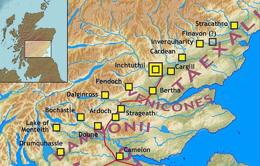
The fort is located in Stirling, east of Drymen.[7] It is associated with the road running from Loudoun Hill past Barochan towards Malling, Bochastle and Dalginross.[8] This road was therefore on the Highland Boundary Fault Frontier.[9]
It may have been on more than one Roman road.[10] It has been suggested that Drumquhassle might be connected to Doune via the Fords of Frew.[11]
The glebblocker forts ran from Drumquhassle to Stracathro.[12] The fort is about 50 m west of a reliable spring which was presumably the soldiers' main water source.[13]
Finds
An enamelled brooch was found as well as some sling bullets.[14] Pottery from Gaul known as Terra Nigra was also recovered.[15] Several coins were also found.[16]
References
- "Drumquhassle". Open Street Map. Retrieved 18 November 2017.
- "Drumquhassle". CANMORE. Royal Commission on the Ancient and Historical Monuments of Scotland. Retrieved 2017-11-18.
- Woolliscroft, D. J. "Drumquhassle". The Roman Gask Project. Retrieved 16 June 2018.
- Keppie, Lawrence (Sep 2010). "The Romans in Southern Scotland: Future Discoveries*". Glasgow Archaeological Journal. 16 (16): 1–27. Retrieved 16 June 2018.
- MASSER, PAUL; BATESON, DONAL; EVANS, JEREMY; WILLIS, STEVEN; ALLASON-JONES, LINDSAY (Sep 2010). "Recent Work at Drumquhassle Roman Fort, Stirlingshire". Scottish Archaeological Journal. 24 (2): 147–168. Retrieved 16 June 2018.
- "Drumquhassle Highland Glen Fort". Roman Britain. Retrieved 16 June 2018.
- "OS 25 inch map 1892-1949, with Bing opacity slider". National Library of Scotland. Ordnance Survey. Retrieved 12 October 2017.
- Keppie, Lawrence; Newall, Frank. "Excavations at the Roman fort of Barochan Hill, Renfrewshire, 1972 and 1984-1986". Glasgow Archaeological Journal. 20 (20): 71. Retrieved 16 June 2018.
- Scottish Naturalist (v.104 (1992) ed.). 1983. Retrieved 16 June 2018.
- Wilson, Allan (Sep 2010). "Roman Penetration in Strathclyde South of the Antonine Wall PART ONE: THE TOPOGRAPHICAL FRAMEWORK". Glasgow Archaeological Journal. 19 (19): 1–30. Retrieved 16 June 2018.
- Page, R.; Page, C. "The excavation of a disused military road at Buchlyvie, Central Region". Glasgow Archaeological Journal. 19 (19). Retrieved 16 June 2018.
- Woolliscroft, D. J. "Drumquhassle". The Roman Gask Project. Retrieved 16 June 2018.
- Woolliscroft, D. J. "FIELDWALKING FINDS FROM THE ROMAN FORTS OF BERTHA, DALGINROSS AND STRAGEATH". The Roman Gask Project. Retrieved 16 June 2018.
- Woolliscroft, D. J. "ARCHAEOLOGY VERSUS TACITUS' AGRICOLA, A FIRST CENTURY WORST CASE SCENARIO". The Roman Gask Project. Retrieved 16 June 2018.
- Hoffmann, Birgitta. "Drumquhassle". The Roman Gask Project. Retrieved 16 June 2018.
- "Drumquhassle Highland Glen Fort". Roman Britain. Retrieved 16 June 2018.
- "Gask Ridge". Scribble Maps. Retrieved 9 June 2018.
- "Gask Ridge Map". HeritageDaily. Retrieved 9 June 2018.