Drayton Bassett
Drayton Bassett is a village and civil parish[3] since 1974 in Lichfield District in Staffordshire, England. The village is on the Heart of England Way, a footpath. Much of the housing is clustered together but more than half is 20th century in the parish as a whole. In the parish is Drayton Manor Theme Park, occupying a large minority of its land.
| Drayton Bassett | |
|---|---|
 The folly-like footbridge and adjacent swing bridge over the Birmingham and Fazeley Canal near Drayton Bassett, one mile from Fazeley Junction | |
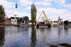
 Drayton Manor Theme Park from across the lake | |
 Drayton Bassett Location within Staffordshire | |
| Area | 12.72 km2 (4.91 sq mi) |
| Population | 1,037 (2011 census)[1] |
| • Density | 82/km2 (210/sq mi) |
| OS grid reference | SK1900 |
| Civil parish |
|
| District |
|
| Shire county | |
| Region | |
| Country | England |
| Sovereign state | United Kingdom |
| Post town | TAMWORTH |
| Postcode district | B78 |
| Dialling code | 01827 |
| Police | Staffordshire |
| Fire | Staffordshire |
| Ambulance | West Midlands |
| UK Parliament | |
North of the adjoining suburb or town of Fazeley is the large town of Tamworth. The eastern lands of the parish form the bulk of Middleton Lakes RSPB reserve which has lakes of various sizes and has replaced an area of gravel workings (excavation).
History
Demographic history
Resident population:
| Year | Population[4] | Houses (recorded from 1831)[5] |
|---|---|---|
| 1801 | 395 | |
| 1811 | 455 | |
| 1821 | 468 | |
| 1831 | 459 | 77 |
| 1841 | 404 | 83 |
| 1851 | 408 | 90 |
| 1881 | 442 | 102 |
| 1891 | 461 | 99 |
| 1901 | 405 | 80[6] |
| 1911 | 370 | not stated |
| 1921 | 365 | 79 |
| 1931 | 523 | 116 |
| 1951 | 562 | 156 |
| 1961 | 767 | 234 |
In 1881 of the 125 working-age men 7⁄10ths were employed as farmers, woodmen or agricultural labourers (87) of whom 63 were the latter and two woodmen.[7] Ten were employed in domestic services or offices (roles), (of which 7 were gardeners)[7] six were "Workers and Dealers in House, Furniture and Decorations" and six "Animals" such as stableman (groom), five were "Workers and Dealers in Various Mineral Substances", the six other pre-written categories including government and professionals numbered not more than three male workers each.[8]
As to the women of like age, 56 did not state a specific occupation or it was deemed illegible, 20 were indoor servants, 2 charwomen, 2 provided (clothes) washing or bathing services, 1 collected tolls, 1 was a warehouseperson or equivalent, one was an agricultural labourer (including farm servant or cottager, cottager still implying of the manor in return for work), one ran a public house/hotel, two worked/dealt in silk, two in tape, fifteen were likely pensioners or widows as in the category with two men of "Persons returned by Property, Rank etc. and not special occupation".[7]
Geographic history
After the Norman Conquest the manor came to the Basset(t) (of Drayton) family until the change of ruling dynasty/faction year 1483, when it passed to the Earls of Leicester. From about 1600 it belonged to the Earls of Essex. It was sold piecemeal but its bulk was sold from the Marquis of Bath to later Prime Minister, Sir Robert Peel (lived 1788–1850) with a certain Mr Wilkes, by hearsay spoken to Arthur Young (agriculturist) for £138,000 (equivalent to £16,700,000 in 2019) in about 1791 as an intensive investment. The creator of the Metropolitan Police Force for London, he often lived in Drayton Manor House (demolished and along with some of its land converted from the agriculture it had been used as for more than 800 years to Drayton Manor Theme Park). Peel is buried in the vault of the parish church. A contemporary quotation of Peel and co-entrepreneur Wilkes' endeavour explains their paternalistic use of cheap labour and pocket boroughs:-
From [Drayton Bassett] we proceeded to Faseley [Fazeley], a part of the same great property, purchased so ably and so fortunately for the promotion of commercial speculation. This is probably the first situation for an inland town that is to be found in Great Britain, for here is the junction of the Birmingham and Coventry canals, which unite Hull, Liverpool, Bristol, and London...here is all that communication can confer: coals under the whole country, offers, perhaps of all others, the most important advantage. Here Messrs. Wilkes and Peele [purchasers mentioned above at a very high price] have built a cotton mill, which is now in full work by day, but never by night, so the objection which has been made on that account to these admirable exertions of human ingenuity do not hold here. This situation is so favourable, in relation to communication, plenty of water, cheapness of coals, and cheapness of labour, that Messrs. Peele and Wilkes may reasonably hope to be the founders of a new town on this centre of all the inland navigations of England; Tamworth is but a mile distant, with an equal command of water and an unemployed poor, a cotton mill, and a printing one are there erected, and other establishments of the same complexion forming, which will in a few years give a new face to the whole neighbourhood. In the evening reach that place, where the people are fond of the idea of by and by rivaling Manchester, and speculative visions are rising in their minds, that they are better situated for a great manufacture... They have between 2500 and 3000 people, and had once a tolerable fabric of narrow cloths, but declined so much that there are not 20 looms left. The manor and antient castle, which frowns upon the town with feudal antiquity, are the property of the Marquis Townshend...; Mr. Peele (in consequence of buying the Marquis Of Bath's estate) [brings in an MP].[9]
The parish lost about 18% then 5% in extent — falling from 3,940 acres (15.9 km2) at some time in 1831 to 1851 then after small shifts fell before 1901 to close to the 3,147 acres (12.74 km2) it reached and then stabilised at on a date in 1941-1951.[10]
The Birmingham and Fazeley Canal and the Tame mark the eastern boundary. The canal can be crossed by a footbridge of simplified, white-painted lightly crenellated form. The village is on the Heart of England Way, a footpath which can also be used by off-road bicyclists.

Famous residents
Rock/pop star Julian Cope lived in the village from the mid-1980s to the early-1990s.
See also
References
- UK Government: Nomisweb: Local Area Report: this Civil Parish (2011 census) Retrieved 2016-05-04.
- "United Kingdom Parliament". Retrieved 18 September 2009.
- "Names and codes for Administrative Geography". Office for National Statistics. 31 December 2008. Archived from the original on 20 May 2011. Retrieved 15 September 2009.
- Total population table "Vision of Britain", the University of Portsmouth and others
- Houses "Vision of Britain", the University of Portsmouth and others
- Since 1 October 1896: a tract of land with 17 houses became part of Canwell parish, per http://visionofbritain.org.uk/unit/10277097
- Table 10 : Occupations of Males and Females in the Division and its Registration Counties "Vision of Britain", the University of Portsmouth and others
- Tabe View: 1881: Occupational Orders "Vision of Britain", the University of Portsmouth and others
- 1791 Tour from Birmingham to Suffolk, Arthur Young, republished here
- Parish extent "Vision of Britain", the University of Portsmouth and others with credit stipulated as required for free non-commercial re-use to David Allan Gatley (School of Social Sciences, University of Staffordshire). Role: transcriber.
External links
| Wikimedia Commons has media related to Drayton Bassett. |
- GenUKI: Drayton Bassett
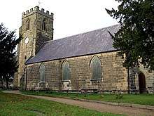
- St Peter's Church, Drayton Bassett [link invalid Feb 5 2020]