Double Peak (Washington)
Double Peak[2] is the descriptive name of a 6,199 feet (1,889 m) double summit located in Mount Rainier National Park in Pierce County of Washington state. Part of the Cascade Range, it is situated northwest of Shriner Peak, south of Governors Ridge, and southeast of the Cowlitz Chimneys.
| Double Peak | |
|---|---|
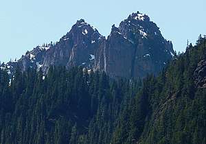 Double Peak seen from Highway 123 | |
| Highest point | |
| Elevation | 6,199 ft (1,889 m) [1] |
| Prominence | 759 ft (231 m) [1] |
| Coordinates | 46°49′43″N 121°34′48″W |
| Geography | |
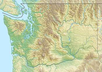 Double Peak Location of Double Peak in Washington  Double Peak Double Peak (the United States) | |
| Location | Mount Rainier National Park, Pierce County, Washington, U.S. |
| Parent range | Cascades |
| Topo map | USGS Chinook Pass |
| Climbing | |
| Easiest route | Scrambling |
Climate
Double Peak is located in the marine west coast climate zone of western North America.[3]
Most weather fronts originate in the Pacific Ocean, and travel northeast toward the Cascade Mountains. As fronts approach, they are forced upward by the peaks of the Cascade Range (Orographic lift), causing them to drop their moisture in the form of rain or snowfall onto the Cascades. As a result, the west side of the Cascades experiences high precipitation, especially during the winter months in the form of snowfall. During winter months, weather is usually cloudy, but, due to high pressure systems over the Pacific Ocean that intensify during summer months, there is often little or no cloud cover during the summer. Precipitation runoff from Double Peak drains into tributaries of the Cowlitz River.[1]
References
- "Double Peak, Washington". Peakbagger.com.
- "Double Peak". Geographic Names Information System. United States Geological Survey. Retrieved 2018-08-11.
- Beckey, Fred W. Cascade Alpine Guide, Climbing and High Routes. Seattle, WA: Mountaineers Books, 2008.
External links
- National Park Service web site: Mount Rainier National Park
- Double Peak photo: Flickr
- Weather: Double Peak