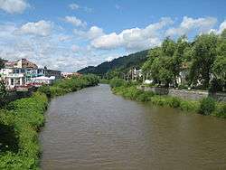
Dorna (river)
The Dorna is a right tributary of the river Bistrița, in Romania.[1][2] It discharges into the Bistrița in Vatra Dornei. It flows through the villages Dornișoara, Poiana Stampei, Podu Coșnei, Dorna Candrenilor and the town Vatra Dornei. Its length is 53 km (33 mi) and its basin size is 608 km2 (235 sq mi).[1]
| Dorna | |
|---|---|
 | |
| Location | |
| Country | Romania |
| Counties | Suceava County |
| Physical characteristics | |
| Source | Călimani Mountains |
| Mouth | Bistrița |
• location | Vatra Dornei |
• coordinates | 47.3452°N 25.3713°E |
| Length | 53 km (33 mi) |
| Basin size | 608 km2 (235 sq mi) |
| Basin features | |
| Progression | Bistrița→ Siret→ Danube→ Black Sea |
Tributaries
The following rivers are tributaries to the river Dorna (from source to mouth):[1]
- Left: Tihul, Dornișoara, Teșnița, Teșna, Izvorul Alb, Doceni
- Right: Bârsaniul, Prislop, Roșia, Alexeni, Negrișoara, Secu, Colăcelul, Pârâul Roșu
gollark: You made Macron *already*?
gollark: Common sense is for other people.
gollark: Worrying.
gollark: Of course.
gollark: The next phase is to write Macron.
References
- Atlasul cadastrului apelor din România. Partea 1 (in Romanian). Bucharest: Ministerul Mediului. 1992. pp. 388–389. OCLC 895459847. River code: XII.1.53.16
- Ovidiu Gabor - "Economic Mechanism in Water Management" (PDF). Archived from the original (PDF) on 5 March 2009., map page 10
This article is issued from Wikipedia. The text is licensed under Creative Commons - Attribution - Sharealike. Additional terms may apply for the media files.