Dolní Třebonín
Dolní Třebonín (German: Unter Breitenstein) is a village and municipality (obec) in Český Krumlov District in the South Bohemian Region of the Czech Republic.
Dolní Třebonín | |
|---|---|
Municipality | |
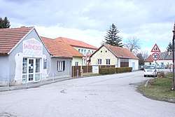 Central part of the village | |
 Flag  Coat of arms | |
 Dolní Třebonín | |
| Coordinates: 48°51′27″N 14°24′21″E | |
| Country | |
| Region | South Bohemian |
| District | Český Krumlov |
| Area | |
| • Total | 20.43 km2 (7.89 sq mi) |
| Elevation | 424 m (1,391 ft) |
| Population (2011) | |
| • Total | 1,212 |
| • Density | 59/km2 (150/sq mi) |
| Postal code | 382 01 to 382 02 |
| Website | web |
The municipality covers an area of 20.43 square kilometres (7.89 sq mi), and has a population of 1,197 (as of 28 August 2006).
Dolní Třebonín lies approximately 9 kilometres (6 mi) north-east of Český Krumlov, 14 km (9 mi) south of České Budějovice, and 137 km (85 mi) south of Prague.
This article is issued from Wikipedia. The text is licensed under Creative Commons - Attribution - Sharealike. Additional terms may apply for the media files.