Dobbin Bay
Dobbin Bay is an Arctic waterway in Qikiqtaaluk Region, Nunavut, Canada. It is located in Nares Strait by eastern Ellesmere Island, south of the Darling Peninsula.
| Dobbin Bay | |
|---|---|
| Location | Nares Strait |
| Coordinates | 79.667°N 73.000°W |
| Basin countries | Canada |
| Settlements | Uninhabited |
Exploration
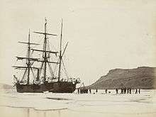
HMS Alert in Dobbin Bay, 1875
During the British Arctic Expedition of 1875 under George Nares, ancient cairns were found on Washington Irving Island, located in the mouth of the bay.[1]
The area was also explored by Adolphus Washington Greely during his expedition of 1881–1884.[2]
gollark: Where *is* that?
gollark: The old version was in rust but this was easier.
gollark: Ah yes, a boxing_glove game, very well known.
gollark: Is this some reference I'm missing?
gollark: I try to get rid of those.
References
- McCullough, K.; Schledermann, P. (Oct 1999). "Mystery cairns of Washington Irving Island". Polar Record. 35 (195). doi:10.1017/s0032247400015643.
- Greely, Adolphus Washington (1886). Three years of Arctic service: an account of the Lady Franklin bay expedition of 1881-84, and the attainment of the farthest north. 2 (Digitized Nov 6, 2008 ed.). C. Scribner's sons. p. 104. ISBN 0-665-08089-1.
This article is issued from Wikipedia. The text is licensed under Creative Commons - Attribution - Sharealike. Additional terms may apply for the media files.