Diège
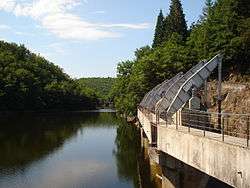
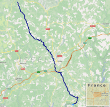
The Diège (Occitan: Dieja) is a 54.4 km (33.8 mi) long river in the Corrèze département, south central France. Its source is at Saint-Setiers, on the plateau de Millevaches, in the parc naturel régional de Millevaches en Limousin. It flows generally southeast. It is a right tributary of the Dordogne into which it flows between Roche-le-Peyroux and Saint-Julien-près-Bort, 68 km (42 mi) southwest of Clermont-Ferrand.
| Diège | |
|---|---|
 | |
 | |
| Location | |
| Country | France |
| Physical characteristics | |
| Source | |
| • location | Plateau de Millevaches |
| • coordinates | 45°43′31″N 02°08′28″E |
| • elevation | 770 m (2,530 ft) |
| Mouth | |
• location | Dordogne |
• coordinates | 45°24′51″N 02°22′52″E |
• elevation | 400 m (1,300 ft) |
| Length | 54.4 km (33.8 mi) |
| Basin size | 508 km2 (196 sq mi) |
| Discharge | |
| • average | 12 m3/s (420 cu ft/s) |
| Basin features | |
| Progression | Dordogne→ Gironde estuary→ Atlantic Ocean |
Its main tributary is the Liège.
Communes along its course
This list is ordered from source to mouth:
Notes
- This article is based on the equivalent article from the French Wikipedia, consulted on 6 May 2009.
gollark: How does ctypes work?
gollark: Hmm, my evil plan to override `7` in Python is failing?
gollark: That does not exist.
gollark: Because it does not scale well.
gollark: Oh bees please don't do it as unicode.
This article is issued from Wikipedia. The text is licensed under Creative Commons - Attribution - Sharealike. Additional terms may apply for the media files.