Devils Point
Devils Point is a point marking the southwest extremity of Byers Peninsula, Livingston Island in the South Shetland Islands, Antarctica[1] and forming the southeast side of the entrance to Osogovo Bay and the west side of the entrance to Raskuporis Cove. The point is separated from Vardim Rocks to the south by Hell Gates. Lucifer Crags, a rocky bluff rising to 81 m at the south extremity of President Beaches, surmount Devils Point on the southwest, Acheron Lake on the northeast and Siren Lake on the east-southeast. The area was visited by early 19th century sealers.
The point was charted and named by James Weddell, Royal Navy, Master of the brig Jane, during the period 1820–23.[1]
Location
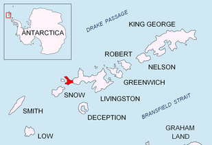
The point is located at 62°40′15.9″S 61°10′57.3″W which is 6.22 km north of President Head, Snow Island, 6.33 km east-southeast of Benson Point, Rugged Island and 16.8 km west by north of Elephant Point. British mapping in 1968, detailed Spanish mapping in 1992, and Bulgarian mapping in 2005 and 2009.
Maps
- Chart of South Shetland including Coronation Island, &c. from the exploration of the sloop Dove in the years 1821 and 1822 by George Powell Commander of the same. Scale ca. 1:200000. London: Laurie, 1822
- Península Byers, Isla Livingston. Mapa topográfico a escala 1:25000. Madrid: Servicio Geográfico del Ejército, 1992. (Map image on p. 55 of the linked study)
- L.L. Ivanov et al. Antarctica: Livingston Island and Greenwich Island, South Shetland Islands. Scale 1:100000 topographic map. Sofia: Antarctic Place-names Commission of Bulgaria, 2005.
- L.L. Ivanov. Antarctica: Livingston Island and Greenwich, Robert, Snow and Smith Islands. Scale 1:120000 topographic map. Troyan: Manfred Wörner Foundation, 2009. ISBN 978-954-92032-6-4
In fiction
Gallery
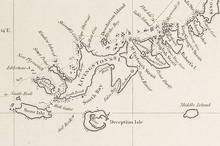 Fragment of George Powell's 1822 chart of the South Shetland Islands and South Orkney Islands depicting Devils Point
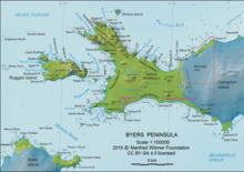 Map of Antarctic Specially Protected Area ASPA 126 Byers Peninsula
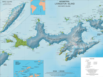 Topographic map of Livingston Island
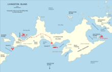 Geography of the novel
The Killing Ship by Simon Beaufort
Notes
- "Devils Point". Geographic Names Information System. United States Geological Survey. Retrieved 2012-01-16.
- S. Beaufort. The Killing Ship. Sutton, Surrey: Severn House Publishers, 2016. 224 pp. ISBN 978-0-7278-8639-2
- The Killing Ship. Susanna Gregory Website, 2019
References
- Devils Point. SCAR Composite Antarctic Gazetteer
![]()