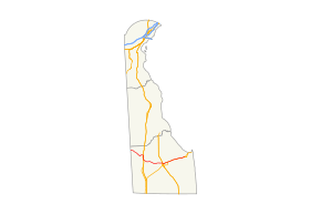
Delaware Route 404
Delaware Route 404 (DE 404) is a major state highway in Sussex County, Delaware that spans the width of the state. DE 404's western terminus is at the Maryland border northwest of Bridgeville, where it continues as Maryland Route 404 (MD 404), and its eastern terminus is at the Five Points intersection with U.S. Route 9 (US 9), DE 1, and US 9 Business (US 9 Bus.). The route passes through rural areas as well as the towns of Bridgeville and Georgetown. DE 404 runs concurrent with DE 18 from east of Bridgeville to Georgetown and with US 9 from Georgetown to Five Points. DE 404 has a business route, DE 404 Bus., that passes through Bridgeville and a truck route, DE 404 Truck, that bypasses Georgetown. DE 404, along with MD 404, serves as a major route connecting the Chesapeake Bay Bridge and the Baltimore-Washington Metropolitan Area with the Delaware Beaches.
| ||||
|---|---|---|---|---|
 | ||||
| Route information | ||||
| Maintained by DelDOT | ||||
| Length | 35.22 mi[1] (56.68 km) | |||
| Existed | 1936[2]–present | |||
| Tourist routes | ||||
| Major junctions | ||||
| West end | ||||
| East end | ||||
| Location | ||||
| Counties | Sussex | |||
| Highway system | ||||
| ||||

DE 404 was first designated by 1936 to run from the Maryland border to DE 18 southeast of Bridgeville. The route was extended to Five Points by 1987. By 1999, DE 404 was aligned to bypass Bridgeville, with DE 404 Bus. designated on the former route through the town. The new alignment of DE 404 around Bridgeville replaced DE 404 Alternate (DE 404 Alt.).
Route description
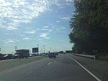
DE 404 begins at the Maryland border, where the road continues northwest into that state as MD 404. From the state line, the route heads southeast on two-lane undivided Seashore Highway, passing through a mix of farmland and woodland with some homes. DE 404 intersects Adamsville Road in the community of Adams Crossroads before it crosses the Marshyhope Creek. In the community of Scotts Corner, the road comes to a junction with the western terminus of DE 36. DE 404 continues through more rural areas and has an intersection with Dublin Hill Road. The route briefly becomes a divided highway before it turns northeast onto two-lane undivided Newton Road, with DE 404 Bus. continuing southeast along Seashore Highway toward the town of Bridgeville. From here, DE 404 heads through agricultural areas to the north of Bridgeville, curving east and crossing the Delmarva Central Railroad's Delmarva Subdivision line at-grade.[3][4]
The route comes to an intersection with US 13 and turns south to form a concurrency with that route on Sussex Highway, a four-lane divided highway. A short distance later, US 13 Bus. splits off at an eastbound right-in/right-out intersection to head southwest into Bridgeville. The road crosses Redden Road and continues through farmland with some businesses to the east of Bridgeville. Upon reaching an intersection with US 13 Bus./DE 404 Bus., DE 404 splits from US 13 by heading southeast onto four-lane divided Seashore Highway. The road passes a few businesses before becoming two lanes and undivided as it continues through agricultural areas, coming to an intersection with DE 18.[3][4]
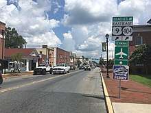
At this point, DE 18 heads east concurrent with DE 404 along Seashore Highway through a mix of farmland and woodland with some residences. The road crosses the Nanticoke River and passes through tracts of the Redden State Forest, heading across Gravelly Branch to the south of Collins Pond and Deep Creek. Farther east, DE 18/DE 404 enters the town of Georgetown and becomes Bridgeville Road, running to the north of the Jack F. Owens Campus of Delaware Technical Community College. The road intersects US 113 and the western terminus of DE 404 Truck in a commercial area and continues east. The two routes head southeast onto North Bedford Street, passing homes and businesses. The road intersects US 9 at a traffic circle called The Circle in the center of Georgetown, where the Sussex County Courthouse is located. Here, DE 18 reaches its eastern terminus.[3][4]
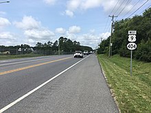
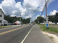
At this point, DE 404 continues northeast concurrent with US 9 on East Market Street through the downtown area. The road crosses the Delmarva Central Railroad's Indian River Subdivision line at-grade and runs through residential areas with a few businesses, passing south of the Southern Delaware Tourism Visitors Center. US 9/DE 404 heads east-northeast out of Georgetown and becomes Lewes Georgetown Highway, passing through farmland and woodland with some development. The two routes intersect the eastern terminus of US 9 Truck/DE 404 Truck a short distance east of Georgetown. In Gravel Hill, the road crosses DE 30. Following this intersection, US 9/DE 404 passes through more rural land, reaching a junction with DE 5 near businesses in the community of Harbeson. Past here, the two routes cross an abandoned railroad line. Farther east, residential development near the road begins to increase, with the road passing through Belltown. Upon reaching the area of the Five Points intersection in Nassau, US 9/DE 404 runs past homes and businesses, widening into a divided highway and coming to an intersection with DE 1D/DE 23. DE 23 joins US 9/DE 404 for a concurrency on a four-lane divided highway before the road comes to a junction with DE 1. Here, DE 23/DE 404 ends, US 9 Bus. continues northeast, and US 9 heads east for a concurrency with DE 1. At this intersection, access from eastbound DE 404 to northbound DE 1 is provided by a reverse jughandle.[3][4]
DE 404 serves as part of a major route connecting the Chesapeake Bay Bridge and the Baltimore-Washington Metropolitan Area to the Delaware Beaches.[5][6] DE 404 also serves as part of a primary hurricane evacuation route from the Delaware Beaches to points inland.[7] The section of the route between DE 5 in Harbeson and DE 1 in Five Points is designated as part of the Delaware's Bayshore Byway, a Delaware Byway.[8] The highest annual average daily traffic along DE 404 is 22,186 vehicles along the US 13 concurrency with the lowest being 4,860 vehicles at the western terminus of DE 404 Bus.[1] All of DE 404 is part of the National Highway System.[9]
History
By 1920, what would originally become DE 404 was an unimproved county road, with the section east of Bridgeville under contract as a state highway.[10] The entire route of what would become DE 404 was completed as a state highway to a point northwest of Bridgeville by 1924.[11] By 1931, the road was built as a state highway northwest to the Maryland border.[12] DE 404 was designated to run from the Maryland border, where it connected to MD 404, southeast to DE 18 southeast of Bridgeville by 1936. The route followed its current alignment to Bridgeville, where it passed through the town on Market Street and South Main Street before picking up its current alignment east of US 13. At this time, what is now DE 404 past its then-eastern terminus was designated as part of DE 18.[2] By 1987, DE 404 was extended east to DE 1 in Five Points, following DE 18 to Georgetown and US 9 (which had replaced a portion of DE 18) from Georgetown to Five Points.[13] DE 404 Alt. was created to bypass Bridgeville to the north and east by 1990, following Newton Road and US 13.[14] The alternate route became a part of mainline DE 404 by 1999, with the former DE 404 through Bridgeville becoming DE 404 Bus.[15]
In 1991, the Five Points intersection was reconfigured to separate the DE 23 and Plantation Road intersection from US 9/DE 404, with a short connector road linking US 9/DE 404 to the two roads. In addition, a jughandle was constructed from eastbound US 9/DE 404 to northbound DE 1. In 2004, the Delaware Department of Transportation (DelDOT) began a study on converting the Five Points intersection into an interchange in addition to developing plans on widening US 9/DE 404 west of the Five Points intersection. Alternatives for these projects were presented at public workshops between 2004 and 2008, although the projects were cancelled due to lack of support and financial limitations.[16]
In June 2007, a $15 million project began that realigned the intersection between US 13 and DE 404/US 13 Bus./DE 404 Bus. in Bridgeville from a skewed intersection to a perpendicular intersection and built service roads on both sides of US 13. The project was intended to improve safety at the intersection, which saw a high accident rate due to its design. Work on the project was completed on May 21, 2009, with DelDOT secretary Carolann Wicks and President of Commissioners for the Town of Bridgeville William Jefferson in attendance at a ceremony.[17][18]
There are plans to reconfigure the intersection between US 9/DE 404 and DE 1D/DE 23 that would realign DE 1D and DE 23 to intersect a longer connector road linking to US 9/DE 404 and build a direct ramp from southbound DE 1 to US 9/DE 404 at the DE 1D/DE 23 intersection. This project is currently in the design phase with construction planned to begin in 2024.[16]
Major intersections
The entire route is in Sussex County.
| Location | mi[1] | km | Destinations | Notes | |
|---|---|---|---|---|---|
| | 0.00 | 0.00 | Maryland state line; western terminus | ||
| Scotts Corner | 3.23 | 5.20 | Western terminus of DE 36 | ||
| Bridgeville | 6.08 | 9.78 | Western terminus of DE 404 Bus. | ||
| 8.22 | 13.23 | West end of US 13 overlap | |||
| Right-in/right-out intersection eastbound; northern terminus of US 13 Bus. | |||||
| 10.72 | 17.25 | East end of US 13 overlap; southern terminus of US 13 Bus.; eastern terminus of DE 404 Bus. | |||
| | 12.37 | 19.91 | West end of DE 18 overlap | ||
| Georgetown | 21.64 | 34.83 | Western terminus of DE 404 Truck | ||
| 22.69 | 36.52 | Traffic circle; eastern terminus of DE 18; west end of US 9 overlap | |||
| Eastern terminus of US 9 Truck/DE 404 Truck | |||||
| Gravel Hill | |||||
| Harbeson | 28.71 | 46.20 | |||
| Five Points | 35.08 | 56.46 | West end of DE 23 overlap | ||
| 35.22 | 56.68 | Eastern terminus; northern terminus of DE 23; western terminus of US 9 Bus. | |||
1.000 mi = 1.609 km; 1.000 km = 0.621 mi
| |||||
Special routes
DE 404 Business
| |
|---|---|
| Location | Bridgeville |
| Length | 3.45 mi[1] (5.55 km) |
| Existed | 1999[15]–present |
Delaware Route 404 Business (DE 404 Bus.) is a 3.45-mile (5.55 km)[1] long business route of DE 404 that runs through the town of Bridgeville. The route begins at DE 404 northwest of Bridgeville, heading southeast on two-lane undivided Seashore Highway through agricultural areas with some homes. DE 404 Bus. enters Bridgeville and heads through commercial areas, turning northeast onto Market Street and crossing the Delmarva Central Railroad's Delmarva Subdivision line at-grade. The route passes several homes before intersecting US 13 Bus. and turning south to join that route on South Main Street. The two routes run through more residential areas before leaving Bridgeville and heading through farmland with some development. The road widens into a four-lane divided highway and heads into a commercial area, intersecting US 13 and DE 404. At this point US 13 Bus. and DE 404 Bus. both end, with the road continuing southeast as DE 404.[3][19] The highest annual average daily traffic along DE 404 Bus. is 7,797 vehicles at the eastern terminus at US 13 and DE 404 with the lowest being 5,344 vehicles at the western border of Bridgeville.[1] None of DE 404 Bus. is part of the National Highway System.[9] DE 404 Bus. was created in 1999 when DE 404 was rerouted to bypass Bridgeville on the alignment of DE 404 Alt.[15] Between June 2007 and May 2009, the intersection with US 13 and DE 404 at the eastern terminus was realigned from a skewed intersection to a perpendicular intersection.[17][18]
Major intersections
The entire route is in Bridgeville, Sussex County.
| mi[1] | km | Destinations | Notes | ||
|---|---|---|---|---|---|
| 0.00 | 0.00 | Western terminus | |||
| 1.84 | 2.96 | West end of US 13 Bus. overlap | |||
| 3.45 | 5.55 | Eastern terminus; southern terminus of US 13 Bus. | |||
1.000 mi = 1.609 km; 1.000 km = 0.621 mi
| |||||
DE 404 Truck
| |
|---|---|
| Location | Georgetown |
| Length | 7.2 mi[20] (11.6 km) |
Delaware Route 404 Truck (DE 404 Truck) is a truck bypass of the section of DE 404 through the town of Georgetown. The route begins at the intersection between US 113 and DE 18/DE 404, heading south along with US 113 on four-lane divided Dupont Boulevard. The road passes through commercial areas with some farmland, reaching an intersection with US 9. At this point, US 113/DE 404 Truck becomes concurrent with US 9 Truck. The road heads southeast through woodland with some farm fields and businesses. US 9 Truck/DE 404 Truck split from US 113 by heading north-northeast on two-lane undivided South Bedford Street Extended. The road passes commercial development before heading through farmland with some homes. The routes curve to the north-northwest prior to heading north. US 9 Truck/DE 404 Truck turn east onto Park Avenue and pass through residential areas before crossing the Delmarva Central Railroad's Indian River Subdivision line at-grade. The road runs through agricultural areas and passes to the south of Delaware Coastal Airport, where it makes a curve to the north. US 9 Truck/DE 404 Truck head through a mix of farmland and woodland with some homes to the east of the airport, crossing the Delmarva Central Railroad's Lewes Industrial Track line at-grade before ending at US 9/DE 404 east of Georgetown.[20]
Major intersections
The entire route is in Georgetown, Sussex County.
| mi[1] | km | Destinations | Notes | ||
|---|---|---|---|---|---|
| 0.00 | 0.00 | Western terminus; west end of US 113 overlap | |||
| 1.16 | 1.87 | West end of US 9 Truck overlap; western terminus of US 9 Truck | |||
| 2.71 | 4.36 | East end of US 113 overlap | |||
| 7.2 | 11.6 | Eastern terminus; eastern terminus of US 9 Truck | |||
1.000 mi = 1.609 km; 1.000 km = 0.621 mi
| |||||
Former DE 404 Alternate
| |
|---|---|
| Location | Bridgeville |
| Length | 4.65 mi[1] (7.48 km) |
| Existed | 1990[14]–1999[15] |
Delaware Route 404 Alternate (DE 404 Alt.) was a 4.65-mile (7.48 km)[1] alternate route of DE 404 that bypassed the town of Bridgeville. It ran to the north of Bridgeville on Newton Road and to the east of Bridgeville on US 13.[21][22] The route was created by 1990.[14] The alignment of DE 404 Alt. was replaced by DE 404 in 1999. The route of DE 404 in Bridgeville then became known as DE 404 Bus.[15]
Major intersections
The entire route was in Bridgeville, Sussex County.
| mi[1] | km | Destinations | Notes | ||
|---|---|---|---|---|---|
| 0.00 | 0.00 | Western terminus | |||
| 2.14 | 3.44 | West end of US 13 overlap | |||
| Right-in/right-out intersection eastbound; northern terminus of US 13 Bus. | |||||
| 4.65 | 7.48 | Eastern terminus; southern terminus of US 13 Bus. | |||
1.000 mi = 1.609 km; 1.000 km = 0.621 mi
| |||||
See also

References
- Staff (2018). "Traffic Count and Mileage Report: Interstate, Delaware, and US Routes" (PDF). Delaware Department of Transportation. Retrieved March 29, 2020.
- Delaware State Highway Department; The National Survey Co. (1936). Official Road Map of the State of Delaware (PDF) (Map) (1936–1937 ed.). Dover: Delaware State Highway Department. Retrieved November 24, 2015.
- Delaware Department of Transportation (2017). Official Travel & Transportation Map (PDF) (Map). Dover: Delaware Department of Transportation. Retrieved August 18, 2019.
- Google (November 16, 2011). "overview of Delaware Route 404" (Map). Google Maps. Google. Retrieved November 16, 2011.
- "Delmarva beach forecast for the 4th of July weekend". WJLA-TV. July 1, 2011. Archived from the original on April 6, 2012. Retrieved November 16, 2011.
- Sottili, Carol (May 20, 2010). "How to beat the beach traffic". The Washington Post. Retrieved April 14, 2012.
- Delmarva Peninsula Evacuation Route Map (PDF) (Map). Delaware Department of Transportation. Retrieved March 22, 2017.
- "Delaware's Bayshore Byway". Delaware Department of Transportation. Retrieved December 30, 2017.
- National Highway System: Delaware (PDF) (Map). Federal Highway Administration. 2010. Retrieved February 10, 2012.
- Delaware State Highway Department (1920). Official Road Map (PDF) (Map). Dover: Delaware State Highway Department. Retrieved November 24, 2015.
- Delaware State Highway Department (1924). Official Road Map (PDF) (Map). Dover: Delaware State Highway Department. Retrieved November 24, 2015.
- Delaware State Highway Department (1931). Official Road Map of the State of Delaware (PDF) (Map). Dover: Delaware State Highway Department. Retrieved November 24, 2015.
- Delaware Department of Transportation (1987). Official State Highway Map (PDF) (Map). Dover: Delaware Department of Transportation. Retrieved November 24, 2015.
- Delaware Department of Transportation (1990). Official State Map (PDF) (Map). Dover: Delaware Department of Transportation. Retrieved November 24, 2015.
- Delaware Department of Transportation (1999). Delaware Official Transportation Map (PDF) (Map). Dover: Delaware Department of Transportation. Retrieved November 24, 2015.
- "Plantation Road Workshop Display" (PDF). Delaware Department of Transportation. February 15, 2018. Retrieved February 24, 2018.
- "Projects - US 13/DE 404 Intersection Realignment and Bridgeville Service Roads". Delaware Department of Transportation. Archived from the original on August 25, 2010. Retrieved February 24, 2018.
- "Event Celebrates Completion of US Route 13/Route 404 Project" (Press release). Delaware Department of Transportation. May 21, 2009. Retrieved February 24, 2018.
- Google (November 16, 2011). "overview of Delaware Route 404 Business" (Map). Google Maps. Google. Retrieved November 16, 2011.
- Google (August 6, 2013). "overview of Delaware Route 404 Truck" (Map). Google Maps. Google. Retrieved August 6, 2013.
- Delaware Department of Transportation (1997). Official Transportation Map (PDF) (Map). Dover: Delaware Department of Transportation. Retrieved November 24, 2015.
- Google (November 16, 2011). "overview of Delaware Route 404 Alternate" (Map). Google Maps. Google. Retrieved November 16, 2011.
External links
