Degerberget Fort
Degerberget Fort (Swedish: Degerbergsfortet) is a modern fort, part of Boden Fortress, outside the city of Boden, Norrbotten, in northern Sweden. The fort was finished in 1908 but improvements were also continuously made during, and between, both World Wars. Besides its military role, the fort also served as storage for part of the Swedish gold reserve for over 40 years. Degerberget Fort was decommissioned in 1992.
| Degerberget Fort | |
|---|---|
Degerbergsfortet | |
| Part of Boden Fortress | |
| Boden, Norrbotten, Sweden | |
 Degerberget Fort | |
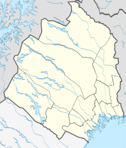
| Coordinates | 65.8598°N 21.6497°E |
| Type | Fort |
| Site information | |
| Owner | Government of Sweden |
| Controlled by | Sweden |
| Open to the public | No |
| Site history | |
| Built | 1901–1908 |
| Built by | Government of Sweden |
| In use | 1908–1992 |
| Materials | Concrete, stone, steel |
| Battles/wars | None |
| Garrison information | |
| Garrison | Around 400 men[1] |
Background
Boden Fortress was built to act as the operational base for all troops attached for the defence of Norrbotten, and serve as a supply fortress for troops stationed between it and the front line, as well as a blocking fortress in case of a Russian surprise attack.[2]
Construction
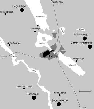
Degerberget Fort was planned and constructed on Degerberget Mountain, north of Boden and west of the lake Buddbyträsket, between 1900 and 1908. It was the only fort in the northern fort group as defined in the 1914 defensive plans for Boden Fortress.[3]
Armament

The main artillery consisted of four 12 cm Kanon m/99, backed up by another four 8.4 cm Kanon m/94-04 which were replaced by 8.4 cm Kanon m/47 in the early 1950s.[4] Surrounded by a caponier ditch on all sides, the fort area also features one observation post, two searchlight sites and two larger bunkers.[5]
History
Part of the Swedish gold reserve was kept here from 1941 to 1982.[5] Degerberget Fort was decommissioned in 1992 together with Gammelängsberget Fort.[6]
Citations
- Kartaschew 2000, pp. 4–6.
- Bergmark 1980, p. 527.
- Nyström 1990, p. 128.
- Persson 2002, page "8 - 9 cm".
- Fästningsguiden n.d., page "Om Bodens fästning".
- Dig Maps 2001.
References
All sources in (in Swedish) unless otherwise noted.
- Books
- Bergmark, Ragnar (ed.) (1980). Bodens kommun: från forntid till nutid. Boden: Bodens kommun.CS1 maint: extra text: authors list (link) CS1 maint: ref=harv (link)
- Forslund, Björn (1988). Fästningsstad i liv och utveckling. Boden: Kungl. Bodens artilleriregemente.CS1 maint: ref=harv (link)
- Högberg, Leif; Ohlsson, Jan Erik (2006). Militär utflykt!: en vägvisare till militärhistoriska sevärdheter i Sverige. Skurup: Fort & Bunker. ISBN 91-973900-8-9.CS1 maint: ref=harv (link)
- Nyström, Bror Oscar; Skeppstedt, Sven, eds. (1990). Boden: fästningen, garnisonen, samhället. Västervik: Ekblad.CS1 maint: ref=harv (link)
- Strömholm, Fredrik (1933). Boden, fästningen och staden: några minnesblad. Boden.CS1 maint: ref=harv (link)
- Törnquist, Leif (2007). Svenska borgar och fästningar: en militärhistorisk reseguide. Stockholm: Medströms. ISBN 978-91-7329-008-1.CS1 maint: ref=harv (link)
- Journals
- Björhammar, Anders (1998). "Sista skottet från fästningen: nu ska Bodens hemligheter bli turistmål". Populär Historia (5): 29–32.CS1 maint: ref=harv (link)
- Ericson Wolke, Lars; Eriksson, Sten Olof; Törnquist, Leif; et al. (2007). "Militära hemligheter: svenska fort och fästningar". Populär Historia (7): 36–46.
- Kartaschew, Kenneth von (2000). "Bodens fästning" (PDF). Tidskriften Kulturvärden (3): 10–15. Archived from the original (PDF) on 2011-09-27. Retrieved 2011-11-18.CS1 maint: ref=harv (link)[ref 1]
- Lidström, Hans (2005). "Rödbergsfortet - Ett monument". Ledaren - Tidskrift för Västerbottens Befälsutbildningsförbund (1): 4. Archived from the original on 2007-09-30. Retrieved 2006-12-27.CS1 maint: ref=harv (link)
- Prage, Göran (2005). "'Bombsäkra' lokaler att hyra" (PDF). Tidskriften Kulturvärden (4): 22–23. Archived from the original (PDF) on 2011-09-27. Retrieved 2011-11-18.CS1 maint: ref=harv (link)
- Svensson, Göran (2000). "Vår första moderna befästning" (PDF). Tidskriften Kulturvärden (1): 14–19. Archived from the original (PDF) on 2011-09-27. Retrieved 2011-11-18.CS1 maint: ref=harv (link)
- "Bodens fästning öppnas" (PDF) (Press release). Statens fastighetsverk. 2000-06-20. Archived from the original (PDF) on 2011-09-27. Retrieved 2011-11-18.
- News
- Anundby, Nils (2006-07-18). "Många myter om fortet". Norrländska Socialdemokraten. Retrieved 2011-11-18.CS1 maint: ref=harv (link)
- Englund, Peter (2005-08-18). "Om terroristskräcken i vårt land". Dagens Nyheter. Archived from the original on 2006-12-14. Retrieved 2007-01-02.CS1 maint: ref=harv (link)
- Hagerfors, Anna-Maria (2002-07-28). "Topphemlig fästning blev turistmål". Dagens Nyheter. Retrieved 2011-11-18.CS1 maint: ref=harv (link)
- PM (2002-08-25). "Turistmålet som skulle stoppa ryssen". Helsingborgs Dagblad. p. 22.
- Råde, Hampus (2004-05-11). "Sveriges hemliga rum". Värnpliktsnytt. p. 17.CS1 maint: ref=harv (link)
- Online
- Bothnian Arc (n.d.). "Kultur & Nöje - Boden". Archived from the original on 2004-11-03. Retrieved 2006-09-04.
- Dig Maps AB (2001). "Bodens fästnings karta". Archived from the original on 2006-06-14. Retrieved 2006-09-04.[ref 2]
- Fästningsguiden i Norr AB (n.d.). "Bodens fästning & Rödbergsfortet". Retrieved 2011-11-18.
- Persson, Mats (2002). "Breech-loaded Guns and Cannon used by the Swedish Armed Forces". Archived from the original on 2007-05-18. Retrieved 2007-06-04.CS1 maint: ref=harv (link)
- Spangsberg, Svend (n.d.). "Bodens fästning - Nordens største bjergforter" (in Danish). Archived from the original on 2008-02-21. Retrieved 2006-09-04.
- Statens fastighetsverk (n.d.). "Bodens fästning". Archived from the original on 2011-09-27. Retrieved 2011-11-18.
- Statistiska centralbyrån (2011). "Price level in Sweden 1830–2010". Archived from the original on 2012-01-13. Retrieved 2011-11-18.
- Other
- Boden Fortress exhibition at Försvarsmuseum Boden. Visited on 2006-07-28.
- Rödberget Fort guided tour by Fästningsguiden i Norr AB. Visited on 2006-07-28.
Reference notes
- A slightly different version of the article which contains some additional information but lacks pictures, is available at sfv.se Archived 2011-09-27 at the Wayback Machine. Citations for pp. 1–7 refers to this alternative version.
- The main page image is missing, but klicking on it bring up parts of the map.