Cwm Twrch
Cwm Twrch is a Site of Special Scientific Interest (SSSI) in Carmarthenshire, Wales.[1][2]
| Site of Special Scientific Interest | |
 Location within Carmarthenshire | |
| Area of Search | Carmarthenshire |
|---|---|
| Grid reference | SN424084 |
| Coordinates | 51.79933°N 3.80342°W |
| Area | 2.4 hectares (0.02400 km2; 0.009266 sq mi) |
| Notification | 1988 |
SSSI
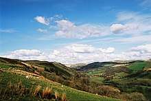
Cwm Twrch SSSI is located on and around the Afon Twrch approximately 0.9 miles (1.4 km) north-east of Ystradowen, and covers 2.4 hectares (5.9 acres).[1][2]
The site is notable for its geology, where river erosion provides the best exposes the Amman Marine Band, a sedimentary layer showing a diverse fauna, and which marks the Westphalian A – Westphalian B boundary in this Carboniferous rock strata.[2]
gollark: Hï.
gollark: > You also agree that unless you disable remote debugging services and/or backdoors in potatOS before installation, data available via these may be used at any time for the purposes of remote debugging, analysis of what potatOS users have installed, random messing around, or anything whatsoever. You also agree that your soul is forfeit to me.
gollark: Or just eat pure calcium.
gollark: Just constantly inject milk into your bloodstream.
gollark: This is unlikely.
References
- "MAGIC Map Application". DEFRA MAGIC Map. DEFRA.
- "Site of Special Scientific Interest, Carmarthenshire, Cwm Twrch" (PDF).
External links
- SSSI Citation for Cwm Twrch
- Citation map for Cwm Twrch
- Your Special Site and its Future - Cwm Twrch SSSI overview from Natural Resources Wales
- Cwm Twrch SSSI marked on DEFRA's MAGIC Map
This article is issued from Wikipedia. The text is licensed under Creative Commons - Attribution - Sharealike. Additional terms may apply for the media files.